Tag Archives: surveying
Add a Drone to Survey Fieldwork
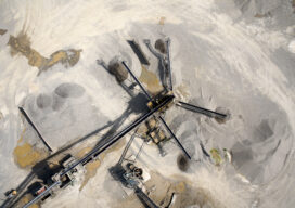
Innovative drones offer a fast, accurate option for large-area survey data collection Since the first use of drones for commercial purposes in 2006, the drone industry has rapidly gained momentum and introduced new capabilities to serve a wide range of applications. Surveying and mapping projects pose unique challenges due to the importance of accuracy and...

Teaching the Ethics of Geo
Maps have always been powerful means of communication, whether etched in cave walls, stone, wood, silver of centuries past, or, in the 20th Century, copper plates and, later, film. In our own century, maps are everywhere—on our phones, computers, fitness apps, and news media, communicating in a myriad of ways about changes over space and...

From Nadir to Oblique
Spic-and-Span Bridges Inspecting the world’s iconic bridges is becoming a UAV job When it was time last year to inspect the Sydney Harbour Bridge, the steel arc structure that spans the harbor of Australia’s capital, authorities Down Under turned to the latest technology available: drones. “The sky’s the limit when it comes to this technology....

Stories from the Field
We celebrate Land Surveyors United’s 16th anniversary with a couple of stories from their website. Dingoes and Tall Tales Dingo is a small town located just across the railway line from the Capricorn Highway in a remote area of Queensland, Australia. The origin of the town’s name is shrouded in mystery. Some say a railway...

The Future of Aerial Photogrammetry
Rapid advances in technology are changing the way we map from the air, but the 100-year-old technology of mapping by crewed airplanes will continue to fly into the future For thousands of years cartographers made maps using tools that mostly measured angles and distances, allowing for positioning of fixed objects over unknown topography. The earliest...

Looking Forward: Scanning History
Looking Forward On a family cruise to Mexico several years ago, I was intent on seeing the Mayan ruins at Tulum. It required a 45-minute ferry from Cozumel to Playa del Carmen and then an hour bus ride to the ruins. With the palm trees, warm Caribbean December breeze, white-sand beaches, and warm aqua water...