Tag Archives: seafloor

Ocean Mapping Effort Makes Progress
Two new partnerships will advance Seabed 2030’s mission to map the entire ocean floor this decade Since ancient Egyptians began studying the Nile River, bathymetry has been the crucial component in hydrography. The great river gave rise to their great civilization, providing fertile soil for farming, water for irrigation, and a means of transportation...

The Ocean Mapping Imperative
Wind and solar-powered uncrewed surface vehicles offer a boost to global surveying efforts. Since 2017, the Seabed 2030 initiative has raised awareness about the importance of mapping the entire seafloor to support a healthy and resilient ocean for the well-being of the entire planet. This partnership between the Nippon Foundation, the International Hydrographic Organization (IHO),...

xyHt News Links: 02/19/16
End-user Requirements for Satellite Imagery/Analytics from the Agriculture, Mining and Forestry Industries Seafloor Announces the Launch of Their Autonomous Surface Vehicles u-blox brings GNSS RTK precision to the mass market TerraGo and Eos Positioning partner on next-generation GPS/GNSS solutions DJI propulsion system aimed at industry, aerial imaging New ‘laspublish’ creates Web Portals for 3D Viewing...

Hydro Insights
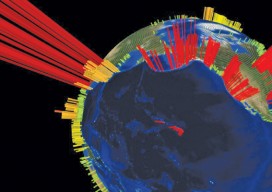
This visualization is of the high volume of commercial shipping activity into and out of ports rimming the Pacific Ocean. The data were analyzed using Esri’s new GIS Tools for Hadoop toolkit. Visualization by Mansour Raad, Esri. Available online at coolmaps.esri.com/BigData/ShippingGlobe with any browser running WebGL. Part 1: Uncharted Depths Editor’s Note: xyHt is honored to...
