Tag Archives: QGIS
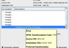
Using OSTN15 with QGIS
As you may be aware, the United Kingdom has a new transformation model that is OSTN15. But why? What does it mean to the geospatial community? Without being too nerdy, tectonic plate movement means that the “model” surface (the geoid) is slowly moving away from being the best fit for the coordinate system. It has...

xyHt News Links: 9/9/16
FireFLY6 PRO Now Shipping! Sokkia introduces lighter and faster line of robotic total stations Septentrio’s Altus NR2 GNSS Receiver is Now Offered by Esri Satlab Geosolutions introduces SLX-1 Multi-application CORS GNSS Receiver [Webinar] The Latest Construction Site Land Surveying Practices Phase One Industrial Innovates Four Band Aerial Imaging Phase One Industrial Launches iXU-RS Aerial Camera...

QGIS 2.14 vs ArcGIS Pro 10.4
This post almost didn’t happen. For over seven years I’ve been comparing GIS software in the hope that someone would be reading and take it upon themselves to fix a few of the issues that we all run into on a daily basis. With the new releases someone told me something, and it almost stopped...
Web Mapping Part 3
Creating a Real Online Map In part 3 of this series (parts 1 and 2 are in the December 2015 and January 2016 issues), we build a web map using Microsoft Windows and Geoserver. We’ll be building this to run on the computer’s “localhost” (http://127.0.0.1), which means that you can run the web map like...

xyHt March 2016 issue
Click here to view the March 2016 issue of xyHt magazine.

Why 3D GIS Is the Future
“The world we live in is a three-dimensional world, so why do we map it and analyse it in just two dimensions?” —Dragons8mycat, 2013 In the last five years, we, the GIS industry, have made some fantastic advances. So, why is it that we are so slow with the adoption of using 3D data? Surveyors...