Tag Archives: #photogrammetry

xyHt Magazine Heights 2022 Issue
Click on the cover to view the Heights 2022 supplement to xyHt magazine. Articles in the issue include: Mapping the Ocean: The need to map the surface of the ocean might seem odd, but as aerial technology advances, it is becoming more and more important. Manned Missions: In the age of unmanned aerial vehicles, the roll of the...

xyHt Weekly News Recap: 09/24/2021
NSPS 21st Annual Student Competition Geo Week 2022 Conference Preview INTERGEO 2021: Relaunch exceeds expectations Teledyne Geospatial Brings CARIS and Optech Together Vexcel Imaging Launches Aerial Camera Solution for Wide-Area Data Collection ConstellR and ScanWorld Partner for High-Value Agriculture Data Data Science Helps Raleigh Avoid Digging Up the Streets Woolpert Develops Guidebook on Airport Response...

Sponsored: Microdrones goes to new ultra heights
Sponsored by Microdrones The new mdMapper3000DuoG VHR takes ultra-high resolution Photogrammetry from higher altitudes. Microdrones is releasing three new Integrated UAV Systems based on the heavy lifting power, resilience and efficiency of the Microdrones md4-3000 aircraft: the mdMapper3000DuoG VHR, the mdMapper3000DuoG and the mdMapper3000 PPK. The company has also updated the mdTector1000CH4 LR with a...
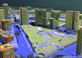
3D Cities from a Single System
Above: This screenshot is of CityMapper output. A look at the hybrid airborne system that combines lidar with oblique and nadir imagery. Over the last five years I’ve built and used a lot of 3D GIS and BIM models. Almost all of this has required the capture of stereo imagery and oblique imagery and a...

In The News: A Geospatial Year at Woolpert 2017-2018
Woolpert has been in business for 107 years, building a strong, broad-based foundation through engineering, surveying, mapping, photogrammetry, lidar collection, GIS, etc., to provide the most comprehensive geospatial support in the industry. In the past year alone our work in each of these sites, represented by these red dots, were spotlighted in the press. They...

HxIP as CaaS
How a prominent manufacturer of mapping airborne sensors and solutions has partnered with customers to expand its global online content service. At HxGN LIVE 2015, the annual exhibition and conference for Hexagon (parent company of Leica Geosystems), CEO and president Ola Rollén spoke about a new area of focus for the company: content services, or...