Tag Archives: Merrick

Point Clouds for Water Conservation
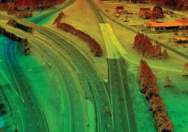
Image above: The Lake Mead region of Las Vegas, Nevada. A project to identify and quantify irrigated landscapes in Las Vegas demonstrates the advantages of using lidar to save precious natural resources. Persistent drought conditions in the western United States are dramatically reflected in the steady diminution, over the past 15 years, of Lake Mead,...

Aerial Imagery to the Rescue
Events in 2017 demonstrated without any doubts or reservations how vitally important georeferenced aerial imagery is in assessing damage and supporting relief efforts following a natural calamity. Last September, an impromptu consortium of companies in North America mobilized their forces and collected and analyzed mountains of data at near cost to help out in what...

xyHt Weekly News Links: 4/21/17
RoboBusiness and TUS Expo Merger Launch of Global Robotics Events and Media Powerhouse Merrick Releases MARS(R) 2017 Software Suite Topcon introduces new GNSS receiver boardswith expanded constellation tracking

xyHt News Links: 04/14/17
MapChecker App by InfoGeographics NovAtel releases Oceanix Nearshore correction service for marine applications Indoor location, data see growth at MWC Trimble’s New Total Station Provides Millimeter Accuracy for Monitoring Applications Merrick Releases MARS® 2017 Software Suite

Closer Than It Looks
Above: High-definition mapping sensors (lidar, digital, and oblique imagery, here mounted on a helicopter during collection of an autonomous vehicle mapping project) provide an accurate, cost-effective approach to limit the interference and potential delays related to collecting extensive control on a right of way. A hybrid of geospatial technologies could help autonomous vehicle mapping drive...

Satellite Imagery’s Impact
Above: The highest resolution of commercial satellite imagery is still more than an order of magnitude lower than the highest resolution attainable from aerial platforms. Keystone Aerial Surveys, Inc. developed this digital surface model from 1.75 cm digital imagery taken with a low-altitude flight. The resolution is sufficiently high to enable its use for mapping...
