Tag Archives: low-distortion map projection
Transformation of Observations, Part 3
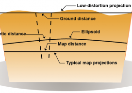
Above: Typical and low-distortion map projections. Using a Project Factor In Part 1 of this series of articles (September 2014 issue), I explained how to transform surface observations into a geocentric coordinate system so that it could be compared to GNSS baseline vectors. In Part 2 (December 2014) I explained how the creation of a...