Tag Archives: laser scanning
Creating Digital Twins for Water Resource Management in Caves
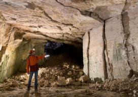
A substantial part of Switzerland’s water resources exist in its complex karst aquifers, a critical natural system that continues to pique the interest of researchers. At the Neuchâtel Centre for Hydrogeology and Geothermics (CHYN), a team of scientists led by Professor Phillipe Renard and accompanied by climate scientist Dr. Tanguy Racine launched an initiative seeking...

Sea Life in Seattle
Laser scanning helped the city create an aquarium great for wildlife and visitors Seattle, Washington, renowned for its vibrant cultural scene and breathtaking natural landscapes, is set to welcome a groundbreaking addition to its skyline: the Seattle Aquarium. Spearheaded by Turner Construction, recognized for its expertise in large-scale projects, this endeavor promises to redefine the...

With friends like these, who needs consumer reviews?
By Matt Kowalski Likely, everyone can agree that we prefer to make informed decisions when spending our hard-earned money. If it is a car, computer, or the pen that I used to write this you can find a consumer report about it. Don’t believe me? Search “pen consumer report.” You will not only find Consumer...

xyHt Weekly News Recap: 05/26/2023
Overture Maps Foundation Names Marc Prioleau Executive Director Phase One Announces iXM-SP150 at GEOINT Trimble Advances Reality Capture with the New X9 3D Laser Scanner Maptitude Revolutionizes School Redistricting Process for Nashua School District Esri Opens New St. Louis Office in Emerging GEOINT District USGIF Announces 2023 Lifetime Achievement Award Recipient Sonardyne upgrade for India’s...

Autonomous Drone Mapping
How interior spaces like mines are being scanned and imaged by a drone that works without a pilot or connectivity. There is a scene in the Ridley Scott-directed 2012 sci-fi thriller “Prometheus” where a deep space exploration crew lands on a planet and discovers an underground labyrinth. They lob a levitating orb down a tunnel,...

New Digital World Needs Data
Next-generation surveyors require specialized education and training to fill the role of geospatial data specialists. Many emerging geospatial applications, such as digital twins, 3D modeling, monitoring, virtual reality, and autonomous vehicles, are based on big digital datasets. Building a 3D digital world starts with accurate data that ties to a point on the ground, so...