Tag Archives: GIS

Do Your Work Right (and You Can Be ‘Smart’ Too)
Ever since I saw the phrase “smart city,” I have cringed. Not because of the term but because of what it alludes to. To me it says that we (geospatial experts) haven’t done our work right. Let me explain. From Wikipedia: “A smart city is an urban development vision to integrate multiple information and communication technology...

GeoBusiness 2016 – London
Wow! Just, wow [ed. Translation to US-English “Wow!!”]. Last week I was at the UK Esri annual conference with 3000+ people crammed into the tight QEII conference centre. This still didn’t prepare me for GeoBusiness this year. It was the same venue as last year but somehow they’ve crammed in a few more stands, and...

xyHt Industry News Links: 4/29/16
Tallysman® Introduces High Performance Triple Band GNSS Antenna + L-Band Trimble Launches End-to-End Field Service Management Suite DJI Introduces Next-Generation Matrice 600 Aerial Platform NovAtel launches 40-centimeter correction service, TerraStar-L The Digit Group and CyberCity 3D Ink Development, Sales and Marketing Agreement Using Streaming 3D Maps for Smart Cities IoT Solutions MIT Develops Control Algorithm...

GISWORX 2016
For most, work is a 9 to 5 grind that slowly eats at your core until you retire, find you have nothing to do, and get bored. Not if you work in the geospatial field though; everyday is a new adventure, and this month took me to the UAE, to be specific, Dubai for the...
xyHt News Links: 4/1/16
East View Now Offering PlanetDEM 30 Plus Trimble Seismic Navigation Systems Support Stakeless Operations for Geophysical Exploration Boundless Launches Complete Open Source GIS Platform for the Enterprise Driverless Conference sparks autonomous car development analysis FARO® Introduces World’s First 3D Scan Localizer and the First FARO Innovation Product Introduction in FARO’s new Early Adopter (EA) Program...
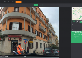
An interview with Mapillary CEO Jan Erik
Following Mapillary’s announcement yesterday, I sought to get more information about Mapillary and how they have come to be such an interesting prospect in the geospatial world. Mapillary is a pioneer in new ways to capture, share, and utilize street-level images. Yesterday I had the privilege to interview Jan Erik Solem of Mapillary to get the...