Tag Archives: GIS

xyHt Weekly News Links: 5/29/2020
*Click here to visit xyHt’s Virtual Trade Show* How you Build Automated CAD-GIS Workflows 5 Questions on the Synergy of BIM and GIS Commercial UAV Expo Europe 2020 Goes Virtual Integrating UAV-based Lidar and Photogrammetry ASPRS Geo Week Goes Virtual Chinese Surveyors Reach Everest Peak
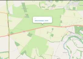
Build a Survey Tracker Map
We all have a little more time on our hands at the moment and it seems like the perfect time to do a little tidy of some of our data and do a little organization. In fact, I’m going to walk you through setting up something that clients have asked me to build for them...
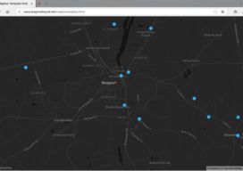
Creating a Web Map Using Mapbox
This blog is born out of pure frustration and my competitive nature. When I was looking at web mapping libraries, I looked at Mapbox and thought, “That will be easy.” Three days later I was pulling my hair out—then the next day I was smiling and happy. You see, Mapbox is similar to Leaflet in...

3D and Geospatial Infrastructure
When I look ahead to the future of geospatial infrastructure and 3D, the words that come to mind are: more, faster, and … more! Humans are poor prognosticators when confronted with exponentially increasing or improving factors, and today we see an explosion of capability and content in the geospatial world that will lead to new...

What Is Automation in GIS Mentoring?
Being asked to write about mentoring, I find myself reflecting on my years in GIS … —The multiple teams I’ve managed and the challenges along the way, plus how I approach leadership or mentoring now, and how my teams go about getting advice when no help is present. First though, what do we mean by...

Let’s Be Colleagues: New Settings for GIS Mentoring
Mentoring is a key aspect in any career; otherwise how do we learn what we need to do and how we need to work in a particular environment? Mentoring is even more important for an SME (small- to medium-sized enterprise) or freelancer. Working on your own is increasingly common in the geospatial field, with the...