Tag Archives: GIS
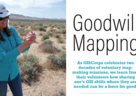
Goodwill Mapping
As GISCorps celebrates two decades of voluntary map-making missions, we learn from their volunteers how sharing one’s GIS skills where they are needed can be a force for good.
Olamiposi Fagunloye – 2025 Young Geospatial Professional
Company: Georgia State University Current position: Graduate Research and Teaching AssistantAge: 26 Education: BS geoscience information system and remoting sensing, Federal University of Technology Akure; MS geological and earth sciences/geosciences, Georgia State University Fagunloye is a graduate research and teaching assistant at Georgia State University in Atlanta. He also worked as an ESG/sustainability intern at the Wylde...
Founders of Atlas – 2025 Young Geospatial Professionals
Harald Rieber, Fredrik Moger, Marius Hofgaard, and Vegard J. Løwe Company: AtlasCurrent position: FoundersAge: 20-something Education: All three graduated from the Norwegian University of Science and Technology GIS can now be considered a legacy product, but these guys are trying to make it cool again by promoting browser-based map-making with their Atlas platform. This is a...

The Future of Geospatial Data Demands a New Approach to Management
Geospatial data serves as the foundation for many mission-critical and time-sensitive applications, including Earth observation, location-based services, defense, population health, and more. However, geospatial data is not just one thing and can be quite heterogeneous, coming in many different forms including point clouds (e.g., lidar and sonar); polygons (e.g. buildings and areas of interest), and...

xyHt Weekly News Recap: 11/01/2024
Topcon Announces Topnet Live Coverage Expansion Across Western U.S., Hawaii Pioneering Tomorrow’s Infrastructure: Highlights from Bentley Systems’ Year In Infrastructure (YII) 2024 Official Geospatial Data Helps Copernicus Map Emergency Responses to Extreme Weather Strong Outlook for Global Sensor Market: Set to Exceed US$250B by 2035 Teledyne Geospatial to Present Preview of Coastal Mapping Solution at...
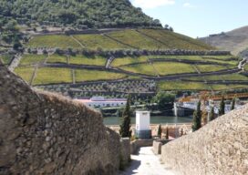
Better Wine with GIS
One of the best vineyards in the world receives care and correction guided by smart maps