Tag Archives: geospatial

Located: April 2025
Compiled by Jeff Salmon Europe Kickstarts its Own Sat-Com The European Union will soon boast its own secure communication satellites system similar to Starlink with the signing of a new space contract in Brussels, Belgium, in December. IRIS², short for Infrastructure for Resilience, Interconnectivity and Security by Satellites, will be composed a multi-orbital constellation of 290...

xyHt Digital Magazine: April 2025
xyHt magazine’s April issue focuses on surveying and takes an in-depth look at the modern state of the art of surveying. As always, if you don’t have a subscription to our print edition, or if someone else in the office has snaffled your copy, don’t fret, here is the digital edition. Click here or on the cover...

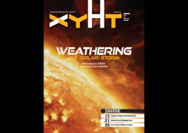
Weathering Solar Storms
Entering the peak year of the current Solar Cycle, GNSS users are already experiencing negative effects. The good news is that there are planning resources, and many of today’s advanced rovers can ride out all but the roughest solar storms.
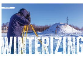
Winterizing
For surveyors, snow and cold can be a real impairment to field work. To some, who choose to bundle up and work through some snow squalls, it may not be as detrimental as rain for completing the field work, but it can still cause a lot of problems.
xyHt Digital Magazine: Feb/Mar 2025
xyHt magazine’s February/March issue highlights mapping and surveying and takes an in-depth look at a few issues involving both. As always, if you don’t have a subscription to our print edition, or if someone else in the office has snaffled your copy, don’t fret, here is the digital edition. Click here or on the cover to the...
Angela Omamuyovwi Anyakora – 2025 Young Geospatial Professional
Company: Sambus Geospatial, Nigeria Current position: Research and Business Development OfficerAge: 27 Education: BS technology, surveying, geo-informatics, Bells University of Technology; MS, geo-information technology, African Regional Institute for Geospatial Information Science and Technology As a professional in the fields of surveying and geospatial analysis, Anyakora brings a unique blend of technical expertise, attention to detail, and a...