Tag Archives: drone

Part 108 Where Are You?
What impact will allowing flights beyond the visual range of the operator have on the mapping industry?
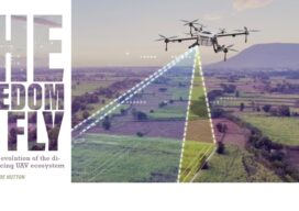
The Freedom to Fly
The Freedom to Fly: The real-time evolution of the direct georeferencing UAV ecosystem

Drone Operators vs. Land Surveyors
Drone Operators vs. Land Surveyors. Are we headed for a confrontation?

It’s a Small (Sensor) World
The fascinating emerging world of geophysical and geological exploration with drones For the last 10 years we have seen more and more applications adopting uncrewed aircraft or drones and adding them to their workflows to expand businesses and offer more versatility to their customers. But like in every other new technology, adoption is not uniform,...

xyHt Weekly News Recap: 01/05/2024
Geo Week to Feature Keynotes on Geospatial Technology Used for Good New Research Harnesses AI and Satellite Imagery to Show Expanding Footprint of Human Activity at Sea IBM Advances Geospatial AI to Address Climate Challenges Collaboration Advances Drone Thermal Mapping Look Ahead: AI, Location Intelligence and Efficiency
xyHt Weekly News Recap: 09/29/2023
Trimble and Kyivstar Partner to Provide GNSS Correction Services for Applications in Ukraine Virtual Surveyor Unveils Photogrammetry App in Major New Release of Smart Drone Survey Software Emlid Releases Reach RS3 GNSS Receiver with Tilt Compensation Esri and NSPS Present Surveyor’s and GIS Webinar Series Thailand to Launch THEOS-2 into Space on October 7th! A...