Tag Archives: Construction CAD Solutions
Caught Mobile Mapping
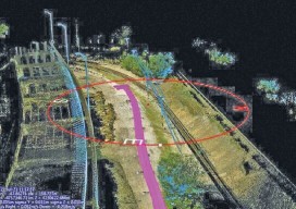
Above: Using a mobile mapping system, Construction CAD Solutions can generate high-accuracy point cloud data–in multiple views, as shown above and at left–to assist in its utility design function. Mobile mapping: A Chicago firm uses lidar innovation to survey for fiber infrastructure–for hundreds of miles. By Larry Trojak The ability to identify, accept, and then...