OPUS Projects Streamlines Submitting GPS Surveys to National Geodetic Survey
By Philippe Hensel with Dan Gillins, Dan Martin and Julie Prusky
“Texas Special Reference Center (TSRC) of Conrad Blucher Institute is leading the efforts toward modernization of the horizontal and vertical datums in the State of Texas, particularly in the subsidence zone in southeast Texas. Horizontal and vertical datum modernization is conducted through multiple GPS survey campaigns utilizing the available NGS geodetic tools and techniques as in OPUS Projects, which include session processing, network adjustments, and publishing the data to the NGS database. Since the fall of 2021, TSRC managed to process and publish two GPS survey projects which provided a densified and reliable geodetic network in the region.”
—Ibraheem Ali, geodist, Conrad Bulcher Institute
NGS’ Online Position User Service (OPUS) Projects software is a tool to process and adjust campaign-style GPS survey data to create high-accuracy geometric coordinates and heights, in alignment with NAD 83 and NAVD 88 (or other local vertical datum). OPUS Projects now integrates the requirements needed to submit a GPS project to NGS for review and publication via NGS Datasheets, greatly simplifying the process of submission.
It also allows users to upload their Real-Time Kinematic (RTK) vectors into their project. This second article in the series on OPUS Projects discusses the benefits of publishing your GPS project.
Already, OPUS Projects seems to be ingraining itself into surveyor’s daily work lives. Participants in a recent OPUS Projects training course registered a three-fold increase in their interest in submitting a project to NGS using the new features available in OPUS Projects.
The National Spatial Reference System
According to the Office of Management and Budget’s draft circular “Coordination of Geographic Information and Related Spatial Data Activities,” the National Spatial Reference System (NSRS) is “the fundamental geodetic control for the United States.” The NSRS is a consistent coordinate system that defines latitude, longitude, height, scale, gravity, and orientation throughout the United States.

Figure 1: On the left: example of a US Coast & Geodetic Survey bench mark. On the right: example of a US Coast & Geodetic Survey triangulation station mark
If you are working on a project funded by a civilian federal agency, you will be required to work within the NSRS. Even if you do not work directly for a federal agency, it is likely that state or local laws will require you to tie your survey to the NSRS. This is historically done by tying to geodetic control in the form of local survey marks (Figure 1) that have adjusted positions and/or heights published on NGS Datasheets.
Back in the day, the U.S. Coast & Geodetic Survey (predecessor to NGS) was the federal agency charged with the task of setting geodetic control across the nation. Since the mid-1990s, and with the advent of GPS, states and municipalities began establishing new geodetic control by submitting their data to NGS for review and inclusion to the NGS database, making it available through NGS Datasheets to the entire surveying community.
NGS remains responsible for managing the national database of geodetic control, but the responsibility for maintaining existing or setting new geodetic control has been passed on to states and local governments, and to surveyors who need to tie to authoritative geodetic control. By submitting your GPS project to NGS, you are creating or updating geodetic control where you need it.
Added Benefits of Submitting your Project to NGS
Keeping Your Coordinates Accurate: If your survey data are submitted for publication, they will likely be included in future national readjustments, so the coordinates will stay accurate for as long as possible. As time passes, and Earth’s land masses slowly move due to crustal motion, coordinates will eventually no longer represent the true locations of the marks.
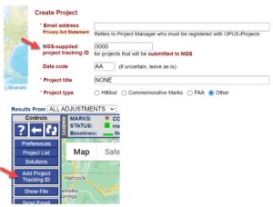
Figure 2: The NGS-supplied project tracking ID can be associated with your project at its inception (top panel), as well as at any other time within the project itself (bottom panel).
For this reason, the entire network of survey control in the NSRS is periodically readjusted, so that the marks remain aligned with the NOAA Continuously Operating GPS Reference System (CORS) Network (also called the NCN). The NCN serves as the primary control for the NSRS.
Aligning your control to the New Datums: Submitting your survey data to NGS today will also ensure that the marks observed in the project will be aligned with the new modernized datums when they are released in the near future. According to the Federal Register Notice (FRN) 16084, “NGS is considering imposing age limits on the observations that will be used in the creation of 2020.00 Reference Epoch Coordinates (RECs), as part of the modernization of the National Spatial Reference System (NSRS).”
When the FRN was published in 2020, the idea was to ensure a maximum number of “fresh” observations on geodetic control marks across the nation. The proposed age limit for the first 2020.00 REC would extend back to January 1, 2010. NGS is currently accepting observations for the 2020 REC through September 2023.
As the FRN goes on to explain, new observations are important to maintain accurate heights, which are critical to the understanding of floods, and the failure to compute heights accurately can have negative impacts on both lives and property.
Helping NGS Build Better Models and Tools for the surveying community: By submitting your project to NGS, you are also helping NGS build better models and tools for the surveying community. Examples of these would include the NGS Coordinate Conversion and Transformation Tool (NCAT), which enables the user to convert coordinates across a variety of datums, realizations, and units.
In the U.S., hybrid geoid models (e.g., GEOID18) rely on the relationship between GPS-derived ellipsoid heights on bench marks with published orthometric heights referenced to a vertical datum. Similarly, NOAA’s Vertical Datum Transformation (VDatum) tool relies on new GPS-based observations on survey marks with orthometric or tidal vertical datums.
Finally, new GPS-based observations in specific areas of rapid land motion help support the NGS Horizontal Time-Dependent Positioning (HTDP) model used to align current GPS-based observations back to the reference epoch of the current geometric datum.
All of these models and tools developed and maintained by NOAA’s NGS rely extensively on user-contributed data, and submitting your project through OPUS Projects is an excellent way to ensure that these tools are kept relevant and useful to you.
OPUS Projects Streamlines Submitting your Project to NGS: Prior to the new version of OPUS Projects, submitting to NGS was a rather laborious and complex process involving a number of different PC executables, downloading CORS data, and having to process and run adjustments on your own. There was a pretty steep learning curve to mastering all of the steps involved in the traditional “bluebooking” process.
The latest version of OPUS Projects gets rid of this cumbersome process. Table 1 summarizes many of the key advantages of OPUS-Projects over traditional bluebooking methods. Only for quick comparison purposes, Table 1 also highlights the differences between OPUS Projects and OPUS Share and OPUS S, although neither of these latter two variants of OPUS can be used for submitting GPS projects to NGS for the establishment of geodetic control.
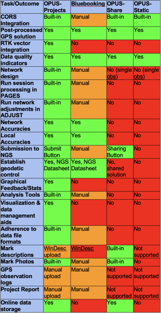
Table 1: Comparison between traditional “Bluebooking” and the different OPUS tools
NGS still accepts projects using manufacturer’s reduction software, but with this latest version, users find using OPUS Projects from start to finish has provided a streamlined way of processing, adjusting, and organizing data for submission to NGS.
So, what does it take to submit your project to NGS?
Submit a survey proposal. This will alert NGS so staff members have the opportunity to weigh in and provide feedback prior to your planned field observations. When your proposal is accepted, you are issued an official NGS Project Tracking ID, which is required to submit your project to NGS (Figure 2).
Create your project in OPUS-Projects
Complete and upload a description file for all marks observed in your project (using WinDesc). A detailed tutorial is included in the OPUS-Projects User Guide, and there are other training materials available (see the NGS Testing and Training web page), including a video.
Upload your GPS observation files and run session and network adjustments
Upload observation log sheets, photos, and a final project report
Click on the “Submit to NGS” button
Conclusions
Recent enhancements to OPUS Projects have greatly streamlined and simplified the process of submitting your GPS project to NGS. Although a few additional steps are required to submit the project to NGS, the user can reap a multitude of benefits, including high local accuracies, updated, authoritative geodetic control where it is needed, alignment with current and future datums, and better geodetic models and tools for the geo-positional activities and needs of the nation.
If you are interested in using OPUS Projects to submit your GPS project to NGS, please visit the OPUS Projects web site, where you will find links to the comprehensive user guide, training videos, and a calendar of upcoming training courses. Also consider contacting your Regional Geodetic Advisors for assistance.