Are you tired of juggling multiple software solutions to manage your geospatial data? Say goodbye to the hassle and hello to GeoMax X-PAD Office Fusion—the all-in-one software integrator designed to revolutionize your workflow. Whether you’re an architect, scaffolder, urbanist, interior designer, or construction professional, this ultimate desktop application is about to become your new best friend.
Why Choose X-PAD Office Fusion?
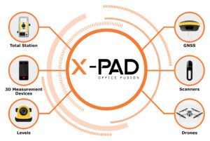
With X-PAD Office Fusion, you can import, process, analyze, and visualize all your geospatial data in a single, unified environment. This comprehensive application seamlessly integrates data from TPS, GNSS, scanners and drones streamlining your entire process from field to design and back again.
Key Benefits:
- Faster Data Collection & Processing: Save time and boost efficiency with rapid data handling.
- Greater Accuracy: Ensure precision in every project with advanced tools.
- Improved Productivity: Work smarter, not harder, with a user-friendly interface and powerful features.
 Applications to Match Your Reality Capture Needs
X-PAD Office Fusion isn’t just about integration; it’s about offering a suite of applications tailored to your specific needs.
Topographic Survey
From import to traverse calculations and reporting, X-PAD Office Fusion supports your every move with all the functions you need to manage survey data effectively.
Surface Calculation
Perform all the surface and volume calculations you need with ease—generate cross sections, handle slide slopes, and manage excavations with advanced tools.
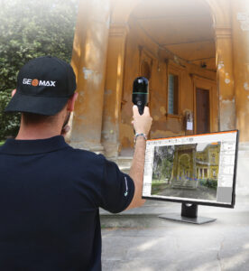
Photogrammetry
Experience photogrammetry like never before with X-Photo Ground and X-Photo Aerial modules. Turn terrestrial and aerial data into rich, detailed visualizations with ease.
Drone Survey
Leverage X-Photo Aerial for processing photogrammetric sets to create dense point clouds, DSM, orthophotos, and 3D meshes. It’s drone surveying, but better.
3D Applications
Manage 3D data effortlessly, from small surfaces to complete Building Information Modeling (BIM) projects. The possibilities are endless.
 Join the Future of Geospatial Data Management
But don’t just take our word for it—hear what satisfied users have to say! Jamie, a respected architect, asserts, “The intuitiveness of X-PAD Office Fusion is what strikes me most about this software—it streamlines my workflow by allowing me to handle all types of data without having to juggle between multiple platforms.” Jamie adds, “When I initially turned to X-PAD Office Fusion, it was to organize my field data. Gradually, however, I uncovered its extensive functionalities, especially the seamless integration with X-PAD365, GeoMax cloud platform.”
Ready to streamline your geospatial workflow? Discover the simplicity and power of X-PAD Office Fusion today. Learn More and Get Started:
https://www.geomax-positioning.com/products/software/x-pad-suite/x-pad-fusion
Why settle for less when you can have it all in one place? Say yes to GeoMax innovation, yes to efficiency, and yes to X-PAD Office Fusion. Welcome to the future of geospatial data management—your projects will thank you!
