Geographic Calculator cloud service is the latest addition to Blue Marble Geographics’ comprehensive suite of powerful coordinate conversion, datum transformation, and format translation tools for geomatics professionals. With access to the largest geodetic parameter database available anywhere, Geographic Calculator Cloud browser-based application has particular strengths in the fields of surveying, geodetics, GIS, or anywhere accurate and reliable positioning capabilities are required. Version 1.0, to be released in the Fall of 2024, will provide core functions of the Geographic Calculator desktop application.
Our geodetic database (“Datasource”) is regularly updated and is always current with the EPSG Geodetic Parameter Dataset. Geographic Calculator also incorporates many of NOAA’s National Geodetic Survey tools and expertise, including the NSRS modernization efforts that are currently in progress. We leverage our thirty years of expertise in coordinate system management software to provide our customers with the most reliable, high-quality tools for processing geodetic data.
 Easy Access to Core Geographic Calculator Features
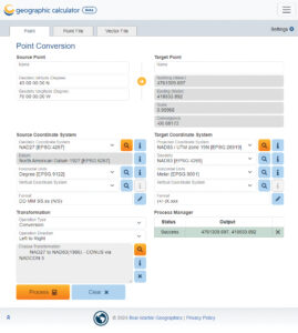
Sign in with an active license from any computer from anywhere with an internet connection, and get right to work. Geographic Calculator Cloud is a browser-based-application. You can search the Datasource, and perform coordinate system conversions and transformations on point, tabular (spreadsheet), or vector data without being tied to any one machine. The extensive list of tabular and vector file formats supported is the same as for the desktop application. Grid-based transformations, as well as forward and inverse calculations, are included in the version 1.0 functionality.
Cloud Hosted
The full GeoCalc Datasource and geodetic engine is hosted in the cloud. Data is processed either locally in browser memory or automatically uploaded to one of three classes of virtual machines for cloud processing, depending on file size, and input/output file types. Input files can be stored locally, on a network drive, or in Azure, AWS, or Google cloud storage.
Fresh Design
The browser interface is a redesign of the traditional Geographic Calculator desktop application’s interface. A flexible, two-column layout will logically reconfigure to a single column for improved performance in smaller windows or on smaller devices. The enhanced design adds colorization to help the user navigate the interface.
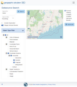
 Full-Featured Search
As the Datasource approaches 10,000 geodetic definitions, Geographic Calculator Cloud provides a live Search page to explore coordinate systems, transformations, or other definitions. Options to search by name, code, or location, and filter by object type are available as well, and WKT or GML definitions can be viewed and copied for use in other applications.
Scalability
Are you an enterprise with many users? Geographic Calculator Cloud allows many users to sign in from anywhere with an internet connection, with a shared “team” usage allocation, all without the need for IT resources installing and licensing multiple machines. Contact us for information about hosting a custom implementation of the service at sales@bluemarblegeo.com.
Explore all the new features available in Geographic Calculator Cloud v1.0 by registering for a 14-day free trial! If you have any questions, please contact us at sales@bluemarblegeo.com