
How mobile mapping is providing a reality capture solution for an ambitious fiber-to-the-home initiative in Ontario, Canada
Investments in fiber-to-the-home or FTTH support digital equity to provide new economic, education, and public health opportunities in rural and remote areas. They also present a potential growth market for surveying companies and utilities service providers as countries across the globe race to meet ambitious broadband expansion goals supported by government investments.
FTTH refers to the use of fiber optic cable to deliver broadband internet connections from a central location directly to the home, known as “the last mile.” FTTH replaces existing copper infrastructure, such as telephone wires and coaxial cable, to deliver higher data speeds, greater bandwidth, and improved reliability for customers.
Global Investment Driving Opportunity
In North America, the Broadband Equity, Access and Deployment (BEAD) program is providing $42.45 billion to expand high-speed internet in the 50 states, District of Columbia, Puerto Rico, and other territories, while in Canada, the Universal Broadband Fund is investing $3.225 billion in FTTH to reach 95 percent of Canadian households by 2026 and 100 percent by 2030.
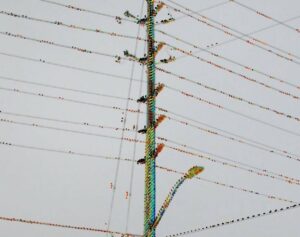
Planning includes taking inventory and measuring equipment attached to existing poles and assessing whether the pole meets the minimum requirements for adding fiber. Photo credit Planview USL.
In Ontario, as many as 700,000 households—approximately 1.4 million Ontarians—lack access to high-speed internet or have no internet connection at all. To help address this issue, in 2021 the Government of Ontario committed nearly $4 billion to achieve 100 percent coverage for unserved or underserved homes in every region by the end of 2025. With eight Internet Service Providers (ISPs) responsible for different regions of the province, work on the Accelerated High Speed Internet Program (AHSIP) is underway.
Background mapping data is fundamental to the network architecture design, according to the FTTH Handbook (Edition 9) from the FTTH Council Europe. While that data can come from national mapping agencies and GIS vendors, an increasingly common source of data is mobile mapping systems, capable of collecting positional data at posted speeds with centimeter-level accuracy.
Mobile mapping data enables planners and designers based in an office to work with a comprehensive view of the real-life situation in the field, thereby avoiding the cost of extra field visits. Information is up-to-date and can be embedded into a GIS for maximum benefit in an integrated environment.
Landbase Details for FTTH
Planview Utility Services Ltd., with offices in Markham, Ottawa, and London, Ontario, provides engineering services, GIS and mapping services, subsurface utility engineering and asset management services to some of the largest utilities and municipalities in Ontario, including several of the ISPs participating in the AHSIP.
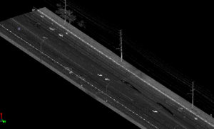
Detailed data is collected to provide a complete picture of the surroundings. Photo credit Planview USL.
Using a Trimble MX50 mobile mapping system, Planview USL has collected more than 18,000 kilometers of comprehensive point clouds and imagery to build a landbase used to design the fiber network for underserved rural communities. The success of the project relies on careful pre-planning to identify potential infrastructure gaps (such as inadequate telephone poles and underground conduits) and difficult terrain, and schedule work within the time constraints of a short construction season.
“It’s a challenge to get survey teams out to remote areas in our vast province, so we need to minimize the number of field visits,” says Tony D’Amico, director GIS services, solutions, and mobile mapping at Planview USL. “Mobile mapping allows us to gather a significant amount of data quickly during the summer months.”
“Our Landbase as a Service (LaaS) offering leverages mobile lidar to efficiently collect data and provide a comprehensive landbase to our clients to support their design work,” D’Amico said. “We spend the winter months creating 360-degree imagery with Trimble Business Center and extracting up to 36 layers of data.”
The data layers include anything above ground that could impact installation of the fiber, including sidewalks, curbs (top of curb, bottom of curb, and back of curb), edge of pavement, ditch lines, tree lines, bush lines, building fronts, fence lines, poles, manholes, catch basins, pedestals, and vaults. The tree component includes tree height, trunk diameter, and canopy diameter. If open-source data is available, parcel maps, zoning, CAD drawings of water pipes, etc., are added to the landbase to provide even more valuable information.
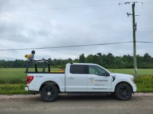
The Trimble MX50 mobile mapping system collects lidar data and 360-degree imagery while driving at posted speeds. Photo credit Planview USL.
Planview USL’s end-to-end workflow is tailored to the specific challenges and opportunities within FTTH deployments. The resulting street-level imagery and landbase layers support planning, design, build, operate/maintain, and expand phases of the FTTH project:
- Planning: 360-degree imagery allows the ISPs to analyze existing conditions and identify potential routes and obstacles without a site visit. By viewing point cloud and imagery data within Trimble MX Publisher, planners gain insight into what equipment is already attached to an existing pole and whether the pole meets the minimum requirements for adding fiber.
- Design: The extracted landbase provides the foundation for FTTH design work, including house and building counts, road conditions, infrastructure locations, and field survey verification. Completing work on budget and on schedule relies on an accurate design.
- Build: Post-construction restoration efforts are backed by the rich data and imagery that documents conditions prior to construction. Additionally, the accurate landbase allows for seamless integration with as-built records.
- Operate & Maintain: Data are used to manage and operate the live network and to support future maintenance, vegetation management, and network upgrades.
- Expand the Network: Ongoing growth is supported through existing datasets available in SHP CAD or through Trimble MX Publisher.
Mobile Mapping for Efficiency and Reduced Cost
Collecting data with a mobile mapping system offers many operational advantages. The georeferenced point clouds and imagery are collected once but used many times for various tasks, including visual asset inspections, ad-hoc measurements, and vegetation management. The landbase captures service area data, generates maps and 360-degree imagery, adds asset attributes, and integrates into a GIS platform.
A vehicle carrying a mobile mapping system like the MX50 operates at normal posted speeds with a two-person team capable of collecting on average 150 to 200 km per day. In five days in the field, 750 to 1,000 km can be collected as compared to several hundred kilometers with traditional terrestrial equipment. Data collection of large areas in a shorter timeframe with a smaller crew results in lower costs for lodging, meals, and travel time, especially when working in remote rural areas.
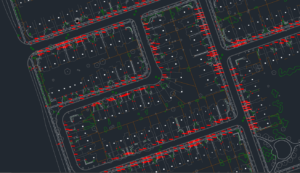
The landbase provides a foundation for FTTH design work. Photo credit Planview USL.
“Compared to other mobile mappers that we’ve owned, we feel the MX50 offers the most user-friendly setup, mounting, software, and navigation and the software is quite intuitive,” says D’Amico. “Even more important is reliability. After driving hours to reach our target area, we really need the unit to work correctly. And if something does go wrong, Cansel, our local dealer, can quickly provide a loaner and send us back to work.”
Mobile mapping has unlocked new customer opportunities for Planview USL and driven hiring within the firm. The telecommunication design teams have significantly grown in recent years, as well as the GIS team that supports the design process and post construction data and asset management for customers. The mobile lidar team, part of the GIS Team, has also grown both in size and resources to meet project demand from telecommunications companies and other engineering firms. Between the collection team, and the data processing and extraction team, employment fluctuates around 65 depending on current project needs.
Creating Opportunities for Underserved Communities
High-speed internet connectivity to every home and business helps to level the playing field for remote and rural communities left out of the growing digital economy. The Government of Ontario’s commitment to invest in FTTH will improve access and create new opportunities for video streaming, cloud computing, virtual reality, remote work, online schooling, and more. Planview USL is contributing to AHSIP by collecting thousands of kilometers of location-based information with its mobile mapping system, and creating the detailed landbase necessary for effective planning, design, and construction of the high-speed fiber optic network in Ontario.