From GIS to satellite remote sensing and street-level imaging, the latest geospatial technologies are behind every successful delivery, down to the very last mile.
In the spring of 1962, Procter and Gamble Company ran a contest based on “Car 54, Where Are You?” a popular TV sitcom at that time. Contestants were asked to help the show’s main characters, Toody and Muldoon, plan their trip to visit 33 cities across the United States. Although the game sounded easy, there was a catch: the duo must take the shortest round-trip route starting from Chicago.
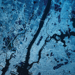
Satellite imagery can provide useful basemaps for extracting the road network of any urban area. Shown here is New York City.
With 54 $1,000 prizes and one $10,000 grand prize at stake, the contest was an instant success. And despite objections that the problem was impossible to crack, entries poured in from the general public as well as members of the academic community. The judges even had to break a tie. Eventually the grand prize went to Robert Karg and Gerald Thompson, researchers at the Carnegie Institute of Technology. The two tapped the institute’s 2,000-pound (910 kg) Bendix G-20 electronic computer to code their proposed algorithm, using as inputs the reported road distances between cities from that year’s Rand McNally Road Atlas. They calculated that the shortest route would take 12,955 miles.
Their $10,000 grand prize may now have been spent, but the article that Karg and Thompson wrote to describe their award-winning solution continues to be cited to this day. That’s because they were one of the first to use an electronic computer to solve the Travelling Salesman Problem (TSP), a classic mathematical enigma that has baffled scientists for almost a century.
First formulated by mathematicians in the 1930s, the TSP proposes to find an efficient solution to the question: “Given a list of cities and the distances between each pair of cities, what is the shortest possible route that visits each city exactly once and returns to the origin city?” The Procter and Gamble contest was clearly a TSP puzzle.
Yet seeking the shortest, or optimal, route between two points is not only a mathematical challenge. Six decades after the contest was won, research advancements in solving the TSP have found applications in fields such as computer science (network optimization), biology (genome sequencing), and geographic information systems, particularly in the field of logistics and last-mile delivery.
On its way
Hurdling the final leg of every transaction is one of the biggest challenges in logistics. It is often called the last-mile delivery, or the shipment of parcels from a distribution center to the customer’s doorstep. A successful last-mile delivery is critical to the success of retail operations because it is the final contact with the client. In general, customers are satisfied and remain loyal when goods arrive on time and in perfect condition.

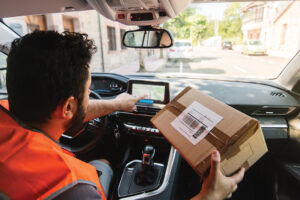
In Southeast Asian cities, motorcyclists are delivering packages while simultaneously mapping the intricate network of city streets.
However, last-mile deliveries continue to be the Achilles’ heel of the logistics industry. According to industry consulting group Capgemini, last-mile deliveries could take up at least 41 percent of the total shipping expenses in a supply chain. Fuel, wages, and vehicle costs, as well as the variable distances between many clients contribute to the ballooning price.
Sending hundreds of packages per day to their final destination is surely an expensive logistical challenge, and it will become even more so in the near future as global e-commerce transactions rise. According to a Bloomberg forecast, online shopping will grow 10 percent annually over the next five years in the U.S. alone, indicating that more and more people will be buying via the Internet and opting for their goods to be delivered at home, mostly located in cities.
Urban dwellers are the most active e-consumers, reports the World Bank, and their shopping habit compounds the last mile problem even more. Cities are densely populated and are often plagued by complicated routes due to unmapped streets, inadvertent road closures and diversions, traffic congestion, and the existence of non-geocoded customer addresses. Given the geographical nature of these issues, it is no surprise that companies are turning to geospatial technologies for solutions.
Take for example United Parcel Service (UPS), one of the world’s biggest logistics companies, and their ORION system. Short for On-Road Integrated Optimization and Navigation, it is the in-house delivery routing platform for UPS drivers and is backed by Esri’s GIS technology.
ORION’s layers of GIS maps, which includes topography, road infrastructure, and traffic movements, took a decade to build before it was first released in 2012 in the United States. The routing platform now handles 66,000 delivery and pickup routes, including locations in Canada and Europe. And with its advanced GIS routing algorithms, every UPS driver receives the very best delivery itineraries in order to reach their customers.
“The Esri platform has been critical for us to enable ORION at UPS,” said Juan Perez, chief information and engineering officer at UPS, in a video message during an Esri event in 2017. “ORION is helping us every single day to get every delivery completed on time at the lowest possible cost.”
The UPS experience shows how building a reliable mapping platform is critical to cut costs in the logistics sector. Yet while transportation networks are difficult to create because of the intricacies of street layouts and the complexity of address systems around the world, doing so within GIS makes the map-building process worthwhile.
 This is because computerized mapping systems have the advantage of analyzing large-scale transportation connections and flows compared to paper-based maps. GIS-based geospatial functions, for example, allow delivery operators to derive the most optimal delivery routes that follow the least-cost paths along any street network, even with multiple recipient points.
Still, many companies fail to notice the vital role that maps play in sorting out the last-mile problem in logistics.
“It’s easy to take maps for granted when they accurately represent on-the-ground truth,” wrote Khaled Naim in a Forbes article. Naim is the co-founder and CEO of Onfleet, a San Francisco-based delivery software company. The company operates worldwide, offering end-to-end route planning to streamline millions of last-mile deliveries for thousands of businesses. “When mapping works, you ignore it because it’s an entirely seamless process.”
Naim discovered this when they first started creating street maps from the ground up during the early days of Onfleet. He and his co-founders spent almost two years collecting geospatial data around the cities of Abu Dhabi, Amman, Cairo, and Dubai to make their maps useful for online commerce. But they found that they needed to focus their mapping efforts on one important area: last-mile delivery.
“We quickly learned that in last-mile delivery, mapping requires different functionality and benefits,” he wrote.
Users view maps differently, according to Naim. For example, customers check maps to assure them that their ordered goods are arriving at the right location, while delivery drivers use maps for road navigation. And as for logistics managers, maps are there to track the drivers in real-time and improve their operations.
With so many uses of maps in order to complete last-mile deliveries, Naim believes in the importance of investing in good mapping. “At the end of the day, if a map is the backbone of your company, it’s worth splurging for quality,” he noted.
Last But Not Least
Even if it is the final stretch in logistics, last-mile deliveries would require the highest quality geospatial data and the latest space technologies. Earth-observation satellites, such as the Landsat and Sentinel constellations, are on top of the list. The imagery that these satellites capture not only shows the earth’s land cover and other geographic features, but they also serve as basemaps which provide the backdrop and geographic context to any mapping endeavor. Imagine viewing a road map without its underlying basemap and it will seem to be just a floating mishmash of lines.
Not all satellite imagery is useful for logistics, however. Images of the earth’s surface captured by the Landsat and Sentinel satellites are only available at the medium-resolution scale, typically between 10 to 30 meters per pixel. Mapping urban roads at the street level, however, requires sharper images, and traditionally they come from pictures taken by aerial photography, or better yet, from very high-resolution satellites.
Several commercial aerospace companies now offer these superior images. Maxar Technologies, a space technology firm based in Colorado, has a repository of high-resolution satellite imagery that can support the creation of road maps. Its imagery database contains 3,000 cities at 30 cm resolution, the perfect level of detail for extracting road vectors as well as other transport information, such as road width and surface type, as well as the locations of roundabouts and traffic lights. A newer satellite program, the Pléiades Neo, also offers the same sub-meter resolution. Owned and operated by Airbus, it has a swath of 14 km and can thus cover the entirety of a mid-size city in one scene. This means more urban roads can be extracted from satellite images compared to aerial photography.
Another geospatial technology that plays a vital role in improving last-mile logistics is Global Navigation Satellite System (GNSS), which includes GPS, GLONASS, Galileo, and BeiDou. GNSS is now being utilized by logistics operators for fleet management in order to track the location of delivery vehicles and make changes in their routes, if needed.
Satellite navigation devices (or satnavs) inside delivery vehicles are constantly connected to GNSS constellations to give the drivers turn-by-turn routing instructions, allowing them to reach their destinations even when road conditions change. Their delivery routes can also adapt to traffic congestion using real-time data, and alternative directions are presented on the fly.
But GNSS can still be improved, especially in cities where high buildings and narrow streets reduce the accuracy of satellite signals received by delivery vehicles. Europe’s Galileo Program aims to achieve this via EGNOS (European Geostationary Navigation Overlay Service). As a GNSS augmentation system, EGNOS uses a set of geostationary satellites and a network of ground stations to increase the accuracy of both GPS and Galileo signals, up to 1.5 meters.
Deliveries have increased due to the rise of e-commerce
Europe is building upon this GNSS milestone to improve the logistics services in the region. The European Space Agency (ESA) announced this year the “Kick-Starts” program will be granting funds to original projects that will use Europe’s satellite data and space-based technologies in providing last-mile delivery solutions.
While Europeans are busy in space, motorcycle drivers in Southeast Asia are diligently delivering parcels and at the same time helping survey the region’s unmapped corners. Grab, a Singapore-based ride-hailing and food delivery company, has equipped their delivery drivers with helment-mounted action cameras that collect street-level images with their corresponding GPS coordinates. Such imagery is rich with hyperlocal information, including points-of-interest (POIs) and road conditions that are usually not found in mapping platforms like Google Maps, Tomtom, and HERE.
Partnering with their own drivers means that Grab can update its in-house mapping platform and receive real-time feedback on conditions of the road and errors in local addresses. Drivers also receive supplemental payments for their mapping work. The collected street imagery is then processed using Edge AI, a type of artificial intelligence that recognizes, classifies, and describes objects.
“We’ve invested to turn this intelligence into a competitive advantage, allowing us to serve our users and partners with a great experience, at the same time driving efficiency and cost-savings for the business,” said Grab’s co-founder Tan Hooi Ling. With more than 33 million POIs and addresses collected, Grab is now the leading last-mile delivery provider in seven Southeast Asian countries.
Aside from Grab, companies like Nextbillion.ai and UNL are also betting on the growth of hyperlocal mapping to meet the growing demand of e-commerce deliveries. Yet, the success of companies such as Grab and UPS is not just because they are using geospatial technologies to improve their last-mile delivery businesses. It’s also because they created their own mapping platforms in the first place and made sure that they functioned in the real-world.
As Jack Levis, the former UPS senior director who backed the creation of ORION, once said in an interview with Esri: “We didn’t create the concept of the traveling salesman problem. We didn’t create the concept of a map. So conceptually, is that innovative? No. It’s innovative because it worked.”