Whether a parcel map is created for an engineering project, land development, valuation, tax assessment, land administration and management, for a subdivision, city, county, or whole country, the tools to create and manage them have dramatically improved.
Surveyors are keenly aware of how much sweat (and tears) can go into the surveying of an individual parcel and for finding, collecting, and evaluating the evidence and records to determine the boundary. Now imagine doing this on a grand scale: for a development, city, county, or even an entire country.
High-count electronic parcel maps representing tens of thousands of parcels are not new. However, the state of digital resources, tools, processing power, and data systems were nowhere near as powerful and sophisticated as they are today.
Parcel Maps
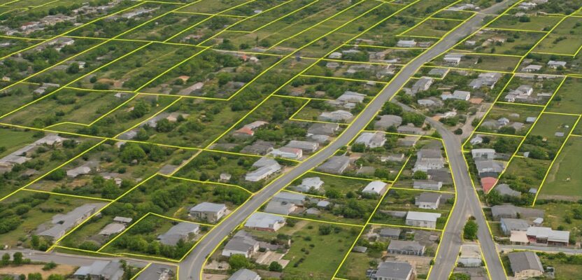
Parcel maps, from a few parcels to hundreds, thousands, or even millions, are subject to the same fundamentals as for an individual parcel: fidelity to the physical evidence on the ground, to the records, to case law, and relationship to adjoining parcels. It’s not just about creating geometry. The key is how well geometry represents the evidence and records.
Recreating that geometry with ink and paper, the standard until the 1980s, required the addition of text and notes to provide the link between evidence and records. But you are working within the bounds of a physical medium. In the electronic age these texts and notes are stored as attributes in a database and tied to original source documents. With such geometry and attributes, digital maps and scale maps can be created for publication if required.
The Fundamentals
Parcel maps can serve a wide spectrum of uses. It might be for tax assessment, where the precision and accuracy may not need to be as stringent as a recorded survey. A parcel map created for inclusion in a set of engineering plans would need to be survey quality, for example, to ensure that constructed elements fall within the subject parcels, easements, and rights-of-way.
A certain class of parcel map, known as a cadastre (or cadaster) may serve as the legal instrument of tenure, title, and/or ownership. There are entire countries where a national cadastre is the official registry of titles. In such cases, Cadastre’s will be held to the same stringent expectations, and workflows as for mapped boundary surveys—plus a few more:
- Physical evidence in the field, where each may apply in the hierarchy of evidence. While this can vary from state or country, such hierarchies can include natural and human-made monuments, evidence of occupation, calls to natural features, etc.
- System of Record. Those officially recorded chains of title, deeds, other records of tenure, and other instruments of conveyance supporting parcel lineage.
- The use of coordinate geometry input tools (COGO) to faithfully “embed” the defining geometry in the electronic medium and tools employed. In addition, there is a need to be able to perform statistical analyses and adjustments (where appropriate) on these geometries.
- Database archiving. While not always required, the ability to access and view a snapshot in time of stored parcel information is becoming increasingly important. This is especially true for cadastres.
- Multi-purpose cadastre. For example, for the parcel map to accommodate other uses, like assessment, public safety, land administration, and management.

Linda M. Foster, PLS, GISP, MGIS Director, Land Records/Cadastre Solutions, Esri.
COGO tools in CAD, civil, and surveying software, due to the inherent data structure for linework elements and adjustment tools, have always been up to the task of parcel creation—but not necessarily at scale, and often with limited capabilities for incorporating records and databases.
While GIS is more data-centric than the precise geometry of CAD, it is far better suited for creating and managing maps with many parcels. Cadastres, especially at a national level, are almost without exception created and managed in GIS. Legacy GIS did not have more than rudimentary COGO tools and presented low-fidelity geometry (i.g., segmented curves) primarily for display purposes. High-fidelity geometries were often created in CAD and imported into GIS. That is still an option, but now this is only one of many options.
GIS parcel maps covering large areas have been around for decades. However, early adopters often needed to do a lot of customization within the base GIS environment. In a way, these pioneers may have become hobbled by their own forward-thinking. Because of such deep-rooted customization, many legacy parcel theme managers felt that migration to new and improved environments was sometimes viewed as too costly and time-consuming. This has changed with advanced out-of-the box functionality.
The tools to create and manage a high-fidelity, precise, and data/record-rich parcel map or cadastre have improved by orders of magnitude. I was among those whose experiences dealing with the sometimes cumbersome, dual-environment reality of legacy parcel mapping have left some scars.
But this has all changed. If today’s tools existed back in the day, there would be many more, high-fidelity parcel maps out there, powering effective management and decision-making, saving time, effort, money, and a lot of frayed nerves.

Tim Hodson, principal product engineer at Esri.
A Fabric
The example that most comes to mind is Esri’s Parcel Fabric, available in ArcGIS Pro. Fabric is a good term for parcel maps and cadastres as metaphor for the interwoven structure (and data) of land parcels. Not an endorsement, but this is among the top solutions I have found yet to undertake such mapping.
An excellent paper on advances in parcel mapping is “Maintaining Cadastral Measurement Data in the Parcel Fabric” (found on www.fig.net). The paper was authored by Tim Hodson, principal product engineer at Esri and presented at the FIG (International Federation of Surveying) Working Week in 2020 in Amsterdam Netherlands. From the paper summary:
“The next generation parcel fabric technology allows cadastral organizations to store parcel-based measurement information as well as its metadata. Organizations that serve as the authoritative source for multi-purpose land parcel information systems require specific metrics on the captured data.”
Such a fabric is not just geometry, but also database driven, and has been a long-desired meld of environments. This not only solves legacy workflow issues but makes the end products, such as web maps, apps, and web services, much more useful.
Cadastral, parcel, and boundary geometries hold much more value if the relationship to the defining records is preserved.
“The data model for the Parcel Fabric starts with the database table we call the “records feature class” said Hodson. “It is basically a table that represents each individual land record. For example, if you have a new subdivision, you create a record in the records feature class. It represents that recorded plat or subdivision document as a single feature. But then, there is a one-to-many relationship from that record to every parcel in the plat that is created via COGO, etc.”
A parcel can have multiple associated record documents. Say that in Hodson’s example, several of the plat parcels are subject to rights-of-way or easements, initially or later; those record documents can be represented and attached to the parcel. The list of scenarios can go on and on. “We are basically managing the parcel fabric as a system of records,” said Hodson.
A key feature of Parcel Fabric is its ability to track historical parcel lineage using link charts. These show a flowchart of the changes between parent and child parcels, that are tracked through edit workflows like a parcel split or a merge of parcels.
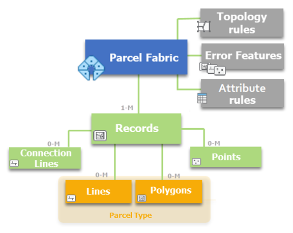
The Parcel Fabric data model
“The records are a driver in many ways,” said Linda M. Foster, PLS, GISP, MGIS director, land records/cadastre solutions at Esri. “Using records, we can also define parcel lineage. That could be chain-of-title in a cadastre. We can model what’s happening over time in our land records or our land system.” Foster also mused about how great it would have been to have such capabilities back when the original Public Lands Survey System (PLSS) of the U.S. was created.
You can add multiple parcel types, defined for your needs.
“Let’s say you have a PLSS section quarter section you’ve resolved,” said Hodson. “You can create separate parcel types for those, for easements, right-of-way, tax parcels, and lots. You can define these when you are setting up your model and add them as needed.”
While in the U.S. there may never be a national or state-level cadastre as the instrument of title registration and ownership, there are maps for tax assessment in nearly every county, city, or state (depending on respective property taxation scenarios). These might range from analog to digital, in CAD or GIS.
“Sometimes they’d take a blueline map, hang it up, take a photo or scan it, and build a tax parcel theme from it,” said Foster. “Now, in addition to those options, you can create the parcels with COGO to get it as precise as you need.”
Expedience and immediate needs drove the creation of many legacy parcel maps (e.g., 9-1-1 modernization in the early 2000s), and often that required compromise. However, even if a low-precision map can serve a great many valid needs, plus or minus one meter, for example, can result in no small amount of consternation for landowners, not to mention heart palpitations in surveyors.
New tools certainly modernize parcel mapping, but also high-resolution aerial (and drone) images, and more highly productive field surveying tools (in the right hands), add to a mix that results in (or, at a minimum, demands) better parcel bases.
In Part 2 will explore how the tools have been made surveyor-friendly, and who’s implementing ambitious parcel mapping programs.