Pangaea Archives
Markets for Geospatial 2017: Part 2, Infrastructure

President Trump’s plan for investing in America’s infrastructure calls for $1 trillion in spending over the next ten years. The specifics of the plan are still a work-in-progress, but with largely bipartisan support, chances are that there will be a big push on infrastructure projects in the coming years, and that should translate into significant […]
Deep-sea Mobile Mapping
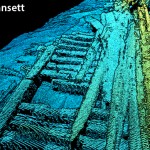
We’re all familiar with lidar-based mobile mapping from ground vehicles, and most of us are aware that aerial lidar is being used effectively to do shallow-water mapping along coastal and riverine projects. Deep-water lidar mobile mapping from an ROV? Well it’s a first for me. Most all of the subsurface surveys I’ve read about were […]
Geospatial on the Big (and Little) Screen

I get excited anytime I see the tools and technology of the geospatial profession in the media. Positive media exposure to the general public of all things geospatial can be a powerful tool to help build awareness for the profession. Additionally, it helps “build the brand” for the next generation, getting them interested in the […]
Straight on to Mars (and Beyond)
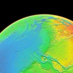
In the last issue we raised the question of whether mankind should go back to the Moon as a way to fuel future space exploration. While that article states the many salient reasons to take this path, many people feel we should aim higher and go straight on to Mars. (For insights on what geospatial […]
Laser-powered UAS
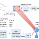
As noted in our latest issue about tethered drones, the ability to power UAS from the ground exponentially increases flight times and allows the use of heavier sensor payloads. Tethering accomplishes this at the cost of range, however: generally 200-400’ with commercially available tethering systems. What if a system had the advantages of tethering and […]
UAVs Planting Trees
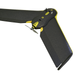
… And What That Means for Next-gen Drones Honestly, I don’t pay much attention to unusual uses of UAVs; I focus on geospatial applications. However, after reading the news about a company using UAVs to plant trees, perhaps I should. Let’s take a look at the story and see what it could mean for the […]