A conversation with EagleView CEO, Piers Dormeyer about aerial imaging markets, value-added services, and what role AI is playing in the sector
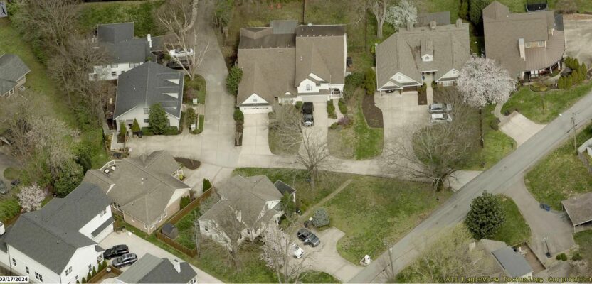
In 2015, I wrote a profile of EagleView, an already prominent aerial image provider, with a massive nationwide library, especially since a merger with Pictometry. The impetus for writing the profile was to explore a growing trend (at the time) of image providers branching into value-added services. For example, a relatively new service (at the time) from EagleView that created canned reports for roofers from oblique images. This became very popular for roofing estimates.
If anything, the same trend has accelerated since, for EagleView and other firms. I have seen many announcements of new services from EagleView and decided to ask the current CEO to briefly outline them, as well as comment on other aspects of the industry.

EagleView CEO, Piers Dormeyer
Schrock: What is new for EagleView over the past nine years?
Dormeyer: EagleView continues to be a leading provider of aerial imagery in North America, and we continue to expand our strategic capture initiatives in top markets with a focus on multiple modalities of imagery capture (drones and aerial intelligence).
We have been experiencing a period of rapid expansion in recent years. In that time, EagleView has been focused on transforming the way that customers in multiple industries access and utilize our aerial imagery. These innovations include the introduction of sub-1 inch image resolution, advanced data ingestion capabilities, improvements to cloud-based dashboards, integrations, and API access, and increases in imagery recency.
Schrock: I see a steady stream of press releases. Notably your Cloud service.
Dormeyer: EagleView Cloud was launched within the last five years. It is our comprehensive imagery and software service. EagleView Cloud is a one-stop shop for geospatial professionals who need access to data and intelligence derived from high-quality and frequently captured aerial imagery to make better decisions. With solutions for government, construction, infrastructure, insurance, solar, and utility providers, this subscription-based service delivers both recency and coverage to enable data-driven decisions and power business growth. For GIS professionals, benefits include integration into workflow, viewing and analysis tools, and an SSO [single sign-in] environment.
Schrock: I see a lot of services that do ‘shake-and-bake’ 3D models from aerial images—from EagleView as well. How would you characterize your modeling service?
Dormeyer: Our clients can access multiple imagery and data solutions within EagleView Cloud’s single sign-on environment as I mentioned. One of those solutions is EagleView 3D, which transforms high-resolution aerial imagery into a full 3D mesh that accurately reproduces small-scale details and provides real-world context and visualization for effective decision-making.
We’ve offered a 3D product in the past, but it required additional viewing software and physical delivery. With the launch of EagleView Cloud, EagleView 3D can be viewed online without complicated setup or installation. It’s exciting to provide this type of solution on account of the wide range of use cases it provides to geospatial professionals and their stakeholders, including urban planning, property assessment, asset management, survey and mapping, utility management, security risk assessment, and many more. EagleView 3D transforms high-resolution aerial imagery into a full 3D mesh model that accurately reproduces small-scale details and provides real-world context and visualization for effective decision-making.
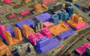
A new service, leveraging its libraries of decades of aerial images that cover 94 percent of the population of the U.S., the Eagle View 3D mesh generation service has been launched. – Source: Eagle View
Schrock: You mentioned sub-1-inch images. I can remember when that kind of resolution seemed only to exist in the realm of spy novels. But now to have it readily available is exciting. I’ve looked at some samples; pretty impressive.
Dormeyer: Certainly; the increasing adoption of 1-inch GSD imagery marks a significant technological leap from 6-inch and 3-inch GSD imagery. This ultra-high-resolution imagery offers unprecedented detail, facilitating more informed decision-making and efficient asset management. EagleView’s 1-inch GSD ortho and oblique imagery allows users to supercharge their GIS by providing 9 times more detail and information than 3-inch GSD imagery. Imagine all of the use cases that can be unlocked with this imagery. Our users are often the ones to show us those use cases.
Schrock: And this is an addition to your existing libraries, how does access look to customers? Surely that’s a lot of data to search through.
Dormeyer: The EagleView Image Library is fairly easy to navigate. With the EagleView Image Library, users can access an extensive archive of high-resolution orthogonal and oblique imagery to make confident and effective decisions. This makes it easier to stream recent and historical ortho and oblique imagery from large areas of interest like multiple counties or entire states directly in EagleView Cloud, receive access to new imagery in designated areas of interest as it becomes available, customize the length of look-back periods to access the specific amount of imagery required and, experience predictable payments with one, easy annual subscription.
Schrock: Has there been particular emerging markets that EagleView has been able to tap into?
Dormeyer: For EagleView, real estate finance firms and property management companies are a core part of our growth strategy. We currently provide access to our extensive imagery library to customers in both these sectors. We’re in the process of launching additional property insight solutions based on our extensive imagery resources to further expand our relevance in this space and better serve this clientele with meaningful data and analytics derived from imagery and geospatial capabilities.
Concurrently, we are looking at additional new markets – architecture, engineering, and telecommunications – where we can expand our strategic capture initiatives and multiple modalities of imagery capture to serve new customers. We are particularly focused on innovative alliances for new market opportunities that complement our technological advances. Anywhere where analytics and intelligence on property attributes can be leveraged and further developed, we feel that EagleView technology and our imagery resources can be the solution.
Schrock: So much gets written about AI lately; how has EagleView adopted elements of AI?
Dormeyer: EagleView has been actively adopting AI into our products for years. We were early adopters of Machine Learning [ML] and AI because we have decades’ worth of aerial imagery covering over 94 percent of the U.S. population. Our library includes over one billion photos each with an average of 24,000 data points. The only way to ingest, analyze, and create value out of that much data is with machine learning.
We use AI in products, like EagleView Assess™, our drone-based roof inspection solution that uses machine learning to continually improve its damage detection capabilities. We also use it within our Roof Reports and Walls, Windows & Doors solutions, where we use artificial intelligence to deliver incredibly accurate property measurements including roof size and pitch. Finally, there is EagleView Data: Structure which provides teams with the ability to superimpose crucial data sets as layers over high-resolution aerial imagery for enhanced analysis and decision-making.
Structures is our latest data offering and is completely and automatically generated using advanced machine learning (ML) algorithms. There’s no manual component and expected accuracy of at least 90 percent. This is obviously for a certain type of use case that can tolerate that threshold, but we can turn this product around in less than a day. Users then receive data layers that can be viewed directly in EagleView Cloud Explorer or integrated into existing GIS systems, including pool outlines, deck outlines, roof outlines, and building outlines, the latter of which is a combination of roof and deck outlines.
But we don’t stop at incorporating ML and AI in our products. I actively encourage us to consider AI capabilities for internal processes (i.e., productivity) as well as those that improve business development and customer needs (i.e. product). Therefore, we encourage testing and adoption by our marketing and sales teams in the same way that we do within our product teams. AI is the future.
While EagleView has taken great strides forward in incorporating machine learning and AI-powered intelligence across our operations, we know there’s a much broader world of innovation and expertise that we want to tap into.