Maps as Art
Street vendors in 18th century Europe hawked just about anything to satisfy the needs of their clients. They sold staples such as fresh fish, meats, kitchenware, as well as the latest fashionable clothes and home accessories. They also peddled maps.
 It was popular back then to hang maps on walls of houses, not only among affluent families, but also in modest homes and workshops. Whatever geographic accuracy that these maps lacked was filled-up instead with an abundance of colorful lines, symbols, and shapes. People bought these decorative maps as status symbols and rarely used them for orientation or navigation. They also offered their owners a snapshot of how the world was expanding in distant lands.
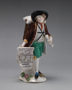
This elegantly dressed-up map seller holds a map showing just that. In his right hand is an unfurled map displaying the North and South American continents bounded in staggered green lines. Check closely and you can see the boundaries of Florida, Brazil, and Peru as they existed during that time.
Toward the Caribbean and the Pacific Ocean are a scattering of islands depicted as dots and colored with tints of orange, yellow, and red. Look for other classic map elements that the designer added to the figure, such as the line of the Equator that divides the map in half, and the bold horizontal line just above the word “AMERICA,” which appears like a scale bar (it’s not). He also holds a rolled-up map in his left hand, and on his back he carries a pack full of other maps. The cartographic business must have been brisk.
Small porcelain figures like this one were once popular items for collecting, and were inspired by Guillaume de Villeneuve’s 13th century poem, “Crieries de Paris” (Street Hawkers of Paris). Made by the Chelsea Porcelain Manufactory in England around 1755, the map seller is now part of the porcelain collection of the Metropolitan Museum of Art in New York. When this small seven-inch figurine was made, much of the western United States has not yet been settled. Clearly, California was not deliberately left out due to lack of space.