By John Welter and Adina Gillespie
From cities to rainforests to glaciers, the evolving application of airborne mapping technology is transforming how we develop, conserve, and maintain crucial environments across the globe. Comprehensive digital twins of entire areas can now be easily generated thanks to advancements in hybrid airborne mapping sensors.
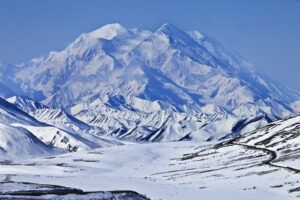
Denali National Park and Preserve, Alaska. Image by National Park Service
These new systems allow simultaneous collection of high-resolution imagery and lidar data, which is crucial for creating digital twins. Advanced capabilities are driving transformative change, from informing sustainable city growth to incentivising conservation efforts.
This article explores three unique stories of how high-resolution data captured from the skies is driving change on the ground: enhancing urban planning in the UK’s historic city of Nottingham, conserving biodiversity in the Costa Rican rainforest, and safely maintaining critical infrastructure built on an Alaskan glacier.
Driving sustainable city growth in Nottingham
To drive more efficient and sustainable urban planning in the UK, there is an increasing demand to see cities and planning processes in 3D. Nottingham City Council set out to do this by creating a complete digital twin of their city. As one of the first UK cities to do so, this project would act as a blueprint for other cities aiming to do the same against tight budgets and emission targets. The aerial surveying company Bluesky International was tasked with collecting the data to generate Nottingham’s digital twin.
With the image and LiDAR data captured in a single flight with a hybrid airborne sensor from Leica Geosystems, part of Hexagon, Bluesky created high-resolution 3D building models and meshes. This hybrid approach cut flying costs and carbon emissions while capturing a total of 7.5 terabytes of data, including 13,885 images, enabling the creation of the city’s digital twin.
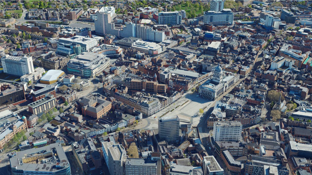
The digital twin of the city of Nottingham in England.
The access to the digital twin of the city increased accessibility, adaptability, and decision-making speed for the council across all departments. The digital twin now enables city planners to visualize proposed developments by inserting 3D building models into the virtual environment, linked with relevant documents such as planning permissions and proposals. Planners can then quickly assess the impact of new developments digitally using tools like line of sight, shadow assessment, and embedded measurements.
This immersive environment supports more sustainable city development by facilitating the accurate planning of green spaces. With developments easily visualized in a photorealistic setting, the digital twin is enhancing transparency and public engagement, enabling changes to be fully understood by all.
3D models have now become fundamental to Nottingham City Council’s assessments, streamlining everything from highway scheme planning to public safety measures, such as flood risk defences or optimal CCTV placement. By deploying the latest aerial mapping technology, Nottingham City Council has positioned itself at the forefront of urban planning practices and established a blueprint for other local authorities across the UK.
Conserving biodiversity in the Costa Rican rainforest
While aerial mapping technology is reshaping urban development, it can also be a vital method to measure and protect the biodiversity of natural habitats. Wildlife populations have declined 69 percent over the past 50 years, according to the World Wildlife Fund––largely due to deforestation driven by livestock farming and palm oil production.
In response to this alarming decline, R-evolution, Hexagon’s green-tech subsidiary, teamed up with La Gamba Tropensation, an Austrian research station associated with the University of Vienna, to preserve and expand the COBIGA corridor, a key rainforest area connecting lowland and upland regions and home to numerous endangered species.
To do this, they needed a way to constantly monitor rainforest health, structure, density, and biodiversity indicators. However, traditional surveying methods were inadequate due to the size and density of the rainforest.
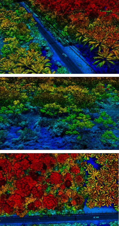
A lidar point cloud of rainforest vegetation in the COBIGA corridor in Costa Rica.
By deploying a combination of a hybrid airborne sensor for large-area data collection and a ground-based handheld scanner from Leica Geosystems, the team captured 100 square kilometres of rainforest with three centimeter accuracy over two weeks in early 2024. Researchers can now visualize and monitor a complete digital twin of the rainforest, with volumetrically precise measurements for quantifying and tracking biodiversity.
One critical part of the mission is ensuring sustainable income for local landowners so they are incentivized to protect and maintain the rainforest. So, the “Green Cubes” approach was developed: each cubic meter of the digital twin is equal to one Green Cube. These Green Cubes can be sponsored by companies worldwide to help them proactively contribute to biodiversity conservation, while also providing a source of income to the local community.
This differs from other corporate offsetting schemes which just plant new trees because it focuses on restoring existing rainforest, while providing a model to accelerate biodiversity conservation globally.
Maintaining the balance in Denali National Park, Alaska
However, in so many places around the world, human construction and nature must co-exist. The advancement of aerial mapping technology has become crucial to manage the intersections of infrastructure and environment where they are most volatile. One instance of this is in Denali National Park and Preserve, Alaska’s most popular tourist destination.
Permafrost thaw is causing the park to shift beneath the very feet of its visitors. Its major roadway is built on top of rock glaciers, which have a core of ice but are covered in rock. The park, which often attracts more than half a million tourists annually, has left many disappointed that full access to some of its most popular sites was curtailed by a major landslide in 2021, triggered by the rapid warming of a glacier on which the roadway was built.
Repairing and maintaining the roadway had been a challenge since it was built in the 1960s, and in response to the 2021 landslide, park officials called on the National Center for Airborne Laser Mapping (NCALM) to create a first-of-its-kind terrain map of the roadway corridor.
Given Alaska’s typically short flying windows due to adverse weather conditions and dramatic elevation shifts around Mount Denali, NCALM used an airborne sensor carrying a lidar and camera system to capture 500-square-kilometers. Compared to traditional methods, this method meant they completed their flight and field operations in nearly half the time.
The resulting model serves as a 2023 baseline, helping Denali officials measure, track, and predict future road movement as thawing continues. Coupled with ongoing elevation mapping, the terrain model not only enables fully informed infrastructure maintenance and repair to keep the park safely open for visitors, but also supports ongoing research into the landscape’s dynamic changes and preparation for the impact of harsh weather conditions and landslides.
Truly global innovation
The evolution of hybrid aerial mapping technologies and techniques is unlocking new ways to tackle critical global challenges. From digitally recreating cities for sustainable development, to enabling new business models for biodiversity conservation, to safely managing infrastructure in changing environments, aerial mapping technology is improving the speed, accuracy, and adaptability with which we build and conserve our world.
As digital processing software and AI capabilities advance, the data we gather will become increasingly insightful and accessible, not just for planners or researchers, but for everyone.
John Welter is the President of Geospatial Content Solutions at Hexagon Geosystems, based in Washington D.C. With three decades of extensive and demonstrated experience in the information technology and services industry, Welter is an expert on topics including geospatial services, airborne mapping technology, big data concepts, and IT strategy.
Adina Gillespie is the Vice President of Strategic Initiatives at Hexagon Geosystems. With more than 15 years of experience in Earth observation (EO) technology, she focuses on advancing technology and data analytics adoption in institutions. Her primary goal is to optimize remote sensing technology utilization in both the public and private sectors.