View From Above – MAPPS and the USDA
By Brian Raber and Brett Thomassie
This is the third article in a series focusing on the geospatial trade association called MAPPS. The first article in the February issue was an interview with Kelly Francis, current MAPPS president. The second article in the June issue discussed the MAPPS Federal Agency Liaisons, and its professional relationship with the National Oceanographic and Atmospheric Administration (NOAA). This article discusses liaison activity with the United States Department of Agriculture (USDA) Geospatial Enterprise Operations (GEO).
Who is MAPPS and What is the Federal Agency Liaison Program?

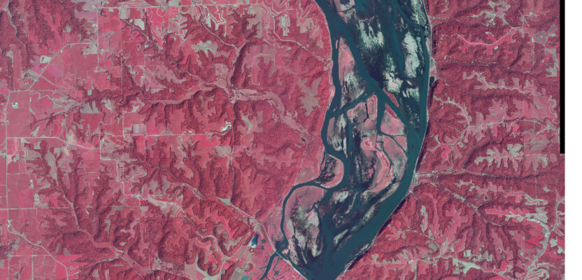
Example of high-altitude four-band NAIP image.
MAPPS is the national association of private firms whose members are “thought leaders” in professional geospatial services and developing innovative technologies.
Through its Federal Agency Liaison Program, MAPPS has communicated and collaborated with various federal agencies since 2003. Agency liaisons are MAPPS members leading open dialog with government agencies on topics of common interest to MAPPS members, federal agencies, congress, and the geospatial community. Its goals are met through engagement in geospatial education and advocacy, non-partisan legislative affairs, and understanding current agency budgets for existing and new programs contracting opportunities.
USDA Geospatial Mission Overview
Created on May 15, 1862, by President Abraham Lincoln, the USDA provides leadership on food, agriculture, natural resources, rural development, nutrition, and related issues based on public policy, the best available science, and effective management. Through its 29 agencies and offices USDA promotes agriculture production that better nourishes Americans while also helping feed others throughout the world; and to preserve our nation’s natural resources through conservation, restored forests, improved watersheds, and healthy private working lands.
The USDA GEO organization is located within the Farm Production and Conservation Business Center (FPAC), providing expertise across the Farm Service Agency (FSA), the Natural Resource Conservation Service (NRCS), and the Risk Management Agency (RMA). GEO serves the FPAC Mission Area with innovative customer-focused geospatial information and solutions that are accessible, current, and authoritative.
World-class Natural Resource Geospatial Data
USDA utilizes its PINE Aerial Imagery Blanket Purchase Agreement (BPA) to contract a wide array of high-resolution, vertical imagery, independent of platform, to support various FPAC Geographic Information System (GIS) programs, including but not limited to resource management, conservation programs, crop compliance, and disaster response. The primary imagery programs are:
- National Agriculture Imagery Program (NAIP) is a multi-agency funded, state-based collection program that acquires high-resolution, orthorectified imagery during “leaf-on” peak agricultural growing seasons. The primary product is the four-band Digital Orthophoto Quarter Quadrangle (DOQQ) file.
- National Resources Inventory (NRI) is a site-based program that acquires very high-resolution, orthorectified imagery to support the NRCS National Resources Inventory (NRI) for “land inventory reflecting soil, water, and related resource conditions.”
- Stewardship Lands (SL) is an easement-based collection program that acquires very high-resolution, orthorectified imagery to support the NRCS conservation easement programs. Stewardship Lands easements can range from less than one acre to as large as 16,000 acres.
- Resource projects are an assortment of very high-resolution imagery collection that support various USDA medium-sized imagery programs. Typically, Resource projects collect both stereo and orthorectified imagery to support United States Forest Service (USFS) resource management, usually ranger district(s) based.
- Ad hoc and Disaster Support Programs cover diverse small to medium-sized geographic areas, high to very-high resolution imagery ad hoc programs. These ad hoc programs may be as simple as a single space-based small scene or a complex large collection that is a leaf-off or leaf-on cloud patched, tone matched, mosaic dataset.

A high-altitude aircraft for NAIP imagery acquisition.
It must also be recognized that USDA NRCS contributes significant funding each year to the United States Geological Survey (USGS) 3D Elevation Program (3DEP).
Future Leaf-off Aerial Imagery Program
A grassroots effort with other federal agencies is underway investigating state-wide leaf-off aerial imagery. This program would increase federal-state partnerships, reduce duplication, maximize government spending, and obtain greater returns on imagery investments.
USDA GEO would provide program coordination and oversight, contracting, management, and quality assurance. Proposed imagery specifications are being discussed with basic requirements such as: four-band imagery, 30-degree sun angle, 60, 30, and 15 centimeter Ground Sample Distance (GSD), and public domain access. Numerous partner-defined options could also be included.
 The National State Geographic Information Council (NSGIC) is actively supporting this investigation by completing an informational survey for leaf-off imagery requirements. Interested parties can provide input on the future program using this QR Code.
Once the “leaf-on” program is ready to launch, MAPPS will be ready to advocate and educate Congress concerning funding and supporting this important USDA GEO program.
MAPPS Members Serving USDA GEO
USDA GEO provides private mapping companies project opportunities through their PINE BPA. Firms supporting the current contract are all MAPPS members:
Aero-Graphics, Aerial Services, Hexagon U.S. Federal, Keystone Aerial Surveys, NV5 Geospatial, The Sanborn Map Company, Surdex, a Bowman Company
MAPPS members have also discussed with USDA ways to create and fund NAIP and were a major contributor in the “Agriculture Improvement Act of 2018” (aka Farm Bill) that was signed into law by then-President Trump, which included NAIP funding language.
Brian Raber is a past MAPPS president and Federal Agency Liaison Coordinator, and recently retired vice president of Merrick & Company.
Brett Thomassie is the MAPPS USDA Liaison and vice president of Federal Business for Surdex, a Bowman Company.

