A model for public-private collaboration
By Michael Shillenn and Bernie Doud
This is the fourth in a series of articles highlighting the MAPPS Federal Agency Liaison Program and its open dialogue with federal agencies to enhance opportunities for MAPPS members and support federal agencies in sustaining and growing their programs, ultimately benefiting all Americans.
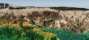
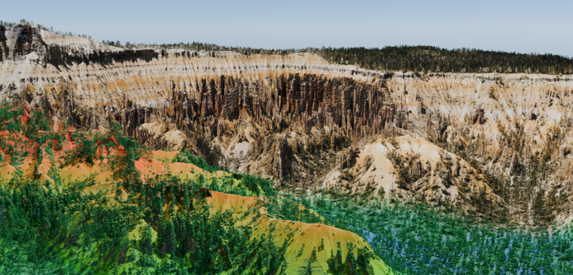
3DEP Visualization at Bryce Canyon, Utah, Courtesy of Aero-Graphics
MAPPS members have a strong interest in U.S. Geological Survey (USGS) programs, contracts, and ongoing collaboration. The enduring private-public partnership between MAPPS and USGS’s National Geospatial Program (NGP) has been a cornerstone in advancing geospatial initiatives critical to the nation’s infrastructure and environmental management.
Decades of dedicated partnership have significantly contributed to the success of key USGS initiatives such as the 3D Elevation Program (3DEP), the 3D Hydrography Program (3DHP), and the Earth Mapping Resources Initiative (EarthMRI).
MAPPS Liaison Program: The MAPPS Liaison Program serves our member firms by fostering meaningful dialogue between the private sector and government agencies. Benefits of the liaison program for MAPPS members and federal agencies are many and include advocating for sound geospatial public policy, aligning business strategies with upcoming opportunities, participating in actionable educational programs, developing relationships with agencies and peers, and promoting small and large business engagement.
About USGS: Within USGS the National Geospatial Program (NGP) provides National topographic information to advance science, support government, enlighten citizens, and enable decision making. With help from the private sector, NGP provides foundational digital geospatial data representing the topography, natural landscape, and manmade environment of the United States making the NGP the optimal choice for MAPPS-USGS engagement focused on supporting numerous key initiatives and programs.
3D National Topography Model (3DNTM): 3DEP and 3DHP programs are components of the 3D National Topography Model (3DNTM), a comprehensive USGS initiative designed to create a high-resolution, three-dimensional representation of the Nation’s topography. The 3DNTM integrates elevation and hydrography data to support a wide range of scientific and practical applications, enhancing our understanding and management of the nation’s natural and built environments.
Strengthening 3DEP: 3DEP systematically responds to growing needs for high-quality topographic data and 3D representations of the nation’s natural and constructed features. 3DEP data are essential for a wide range of applications, including flood risk management, infrastructure development, natural resource conservation, and disaster response.
Since 3DEP’s first full year of production in 2016, MAPPS and its member firms have worked closely with USGS to foster strong partnerships by actively educating potential collaborators and advocating for their involvement. This collaborative approach has expanded the user community, ensuring continued funding, participation, and the sustainable evolution of the 3DEP program.
The partnership between MAPPS and USGS has also been pivotal in driving the adoption of advanced technologies and methodologies for elevation data collection, significantly enhancing operational efficiencies. Looking ahead, this partnership aims to further expand the program’s reach, integrate even more innovative technologies, and ensure comprehensive, high-resolution, current elevation data coverage across the nation.
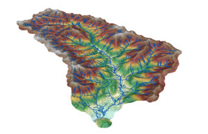
3DHP Network, Sullivan Creek, WA- Headwaters to Sullivan Lake, Courtesy of NV5 Inc.
Advancing 3DHP: The 3D Hydrography Program (3DHP) is another critical initiative that benefits from the MAPPS-USGS partnership. 3DHP aims to develop a comprehensive, high-resolution 3D hydrography dataset that supports water resource management, environmental protection, and infrastructure planning. The collaboration has focused on integrating cutting-edge technologies and best practices in hydrography, resulting in more accurate and detailed water data.
MAPPS’ member firm expertise in data acquisition and processing has been vital in the transition to an operational status starting in 2024. As with 3DEP, MAPPS has been instrumental in advocating for 3DHP, securing funding, and fostering partnerships with other federal agencies and stakeholders.
Enhancing EarthMRI: Launched in 2019, the Earth Mapping Resources Initiative (EarthMRI) is designed to improve the understanding of America’s mineral resources through advanced mapping and data collection with help from the private sector. This initiative supports the nation’s economic and national security by identifying critical mineral resources and informing sustainable development practices. MAPPS liaisons have closely collaborated with USGS to promote the initiative, facilitate partnerships, and ensure the program receives the necessary support and resources.
Engagement: MAPPS engagement with USGS occurs in numerous venues and formats. USGS representatives consistently attend and present at the MAPPS winter and summer conferences, briefing our membership on the latest programmatic and contract status. USGS and MAPPS have collaborated to develop extended workshops to seek membership input on the 3D Nation Elevation Requirements and Benefits Study and the 3DNTM initiative and component programs, 3DEP and 3DHP.
Lastly, the MAPPS Federal Programs Conference is held each spring in Washington, D.C., for our membership to receive direct briefings from agencies. Members also take the opportunity at that time to advocate for geospatial programs with elected officials on Capitol Hill as part of MAPPS business.
Contracting Opportunities: The USGS Geospatial Products and Services Contracts (GPSC) is a comprehensive suite of contracts utilized by federal, state, and municipal governments, as well as non-profits, Tribes, and private entities, to meet their geospatial data needs in partnership with USGS. Now in its fourth iteration, GPSC represents USGS’s long-standing commitment to collaborating with the private sector to provide foundational data for 3DEP and 3DHP as well as a wide range of services and capabilities to meet other diverse geospatial data requirements.
Awarded through qualification-based architect-engineer (A&E) contracting, GPSC comprises a pool of 10 large and small businesses, all of which are MAPPS members. These firms also partner with numerous other MAPPS members through subcontracting arrangements. MAPPS liaisons are crucial in monitoring the use of GPSC, communicating overall contracting status, small business utilization, current and future requirements, and contract renewal.
Conclusion: The successful working relationship between MAPPS and USGS exemplifies the power of public-private collaboration in advancing geospatial programs that are vital to the nation’s well-being. Through the efforts of the MAPPS federal liaisons and the collective expertise of MAPPS members, programs like 3DEP, 3DHP, and EarthMRI have achieved significant milestones. This partnership continues to drive innovation, improve data quality, and support the diverse needs of stakeholders across the country.
As these programs evolve, the MAPPS-USGS collaboration will remain a cornerstone of geospatial excellence, ensuring that the United States remains at the forefront of geospatial science and technology.
Michael Shillenn, CP of NV5 Inc. is a MAPPS director and the senior MAPPS co-liaison to USGS.
Bernie Doud, CP, GISP of Aero-Graphics is also a MAPPS co-liaison to USGS.