This is the second in a series of four articles that highlights the MAPPS Federal Agency Liaison Program with federal agency partners and specifically with the National Oceanic and Atmospheric Administration (NOAA) where MAPPS member firms have a strong interest in programs, contracts, and ongoing collaboration. By developing and continuing impactful relationships with federal agencies like NOAA, we seek to improve opportunities for MAPPS member firms and help our federal partners sustain and grow their programs, which ultimately benefit all Americans. The first in this series appeared in the February issue and can be found here.
MAPPS Liaison Program

The CZML one could be seamless topobathy DEM created by merging topobathy lidar data and MBES data or seamless topobathymetric DEM of the Lower Withlacoochee River. Courtesy of Dewberry
The MAPPS Liaison Program, designed with member firms in mind, works to foster dialogue between the private sector and its government partners and offers opportunities to shape the discussion of issues and programs of interest to our industry. Through the program, we learn and understand what agencies’ funding priorities are, determine if they align with MAPPS’ interests, and educate stakeholders on the importance of these programs.
Our work to advocate on behalf of member firms helps shape public policy and supports legislative advocacy for the geospatial community. We also promote opportunities in the mapping community through involvement in their programs and contract opportunities.
As the MAPPS liaison with NOAA, my role is to partner, collaborate, support, coordinate, report, and communicate between NOAA and the MAPPS Liaison Coordinator, the MAPPS board, and MAPPS membership.
About NOAA
NOAA, which plays a key role in shaping policies for our nation’s oceans, fisheries, climate, space, and weather industries, is an obvious choice for the MAPPS Liaison Program. NOAA’s National Ocean Service (NOS) oversees most of the NOAA geospatial contracts that are of interest to the MAPPS community.
“Geospatial information is at the core of supporting NOAA’s mission. Geospatial technologies provide the framework to collect, store, analyze, and disseminate ‘NOAA’s Environmental Intelligence.’ NOAA is also the authoritative source for multiple national datasets that form the foundation for the National Spatial Data Infrastructure, to include geodetic control, nautical charts, coastal elevation, weather and climate models, critical habitat, and satellite and observational platforms.” Read more at www.noaa.gov.
NOAA Contracts of interest
Three contracts of specific interest to our member firms support NOAA’s mission areas and contribute to the long-term sustainability of our coastlines. These include:
- NOAA OCM’s Coastal Geospatial Services Contract, which offers government entities the ability to obtain geospatial-related services from the nation’s most qualified geospatial firms.
- NOAA NGS’ Shoreline Mapping Services Contract focuses on updating the nation‘s shoreline and nearshore bathymetry needs for application to NOAA Nautical Charts and other coastal applications.
- NOAA OCS’ Hydrographic Services Contract, which offers government entities and nongovernmental stakeholders a vehicle to reach the industry’s most qualified vendors to fulfill bathymetric data acquisition and processing needs.
Collaboration Among MAPPS and NOAA
MAPPS’ alignment with the mission, objectives, and programs of NOAA is critical to the success of the organization. In addition, MAPPS offers opportunities to learn from, work with, and support NOAA representatives. OCM Science and Geospatial Services Division chief Nicholas (Miki) Schmidt, and NGS chief of the Remote Sensing Division Mike Aslaksen routinely attend MAPPS events and work with MAPPS to support mutual endeavors.
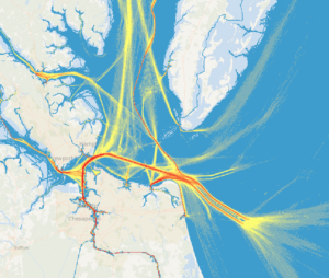
AccessAIS is a temporal geospatial app published within NOAA and BOEM’s Marine Cadastre program that enables users to interactively download U.S. vessel traffic data across user-defined geographies and time periods. Photo courtesy of Dewberry
In January, the newly appointed NOS deputy assistant administrator for navigation, observations, and positioning, Rachael Dempsey, spoke at a MAPPS conference to discuss NOAA’s plans to support public safety, coastal and riverine mapping, and the blue economy. In March, at the annual MAPPS Federal Programs Conference legislative affair meeting in Washington, D.C., NOAA NGS director Juliana Blackwell was the keynote speaker. MAPPS members then met with their elected representatives on Capitol Hill to educate lawmakers about important funding initiatives that support the critical work NOAA provides to the nation and our communities.
One critical NOAA program is known as Digital Coast, which MAPPS worked jointly with NOAA and other stakeholders to achieve authorization by Congress and provides data, tools, training, and information needed to help coastal communities plan for resiliency and manage natural resources.
Celebrating NOAA-Focused Geospatial Projects
Every year, MAPPS celebrates its small and large business members, world-class technologies, and professional services via the MAPPS Geospatial Excellence Awards. Past winners of excellence awards related to NOAA include next generation topo-bathymetric lidar, data management of marine cadastre, unmanned aerial shoreline verification, marine minerals information system, autonomous vessel research, and hurricane/emergency response. This is yet another example of how NOAA and MAPPS created a strong public-private partnership for the benefit of the entire geospatial community.