Forester Eli Jensen takes an innovative approach to the future of tree surveys
By Mack Kowalski
There are a few sentences that will instantly transport me back to my childhood. Smokey the Bear’s iconic phrase, “Only you can prevent forest fires!” is definitely one of them.
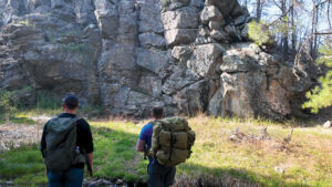
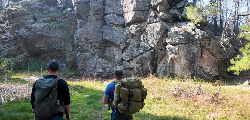
Eli Jensen and the author hiking in a forest in Arizona discussing Jensen’s innovative methods.
Smokey’s campaign was so effective it had me scolding my father for tossing a cigarette out of the window of his Eddie Bauer edition Ford Bronco, and while this message played a crucial role in teaching youth how to help prevent forest fires, it turns out that the message wasn’t 100 percent accurate. I recently traveled to Flagstaff, Arizona, and spent some time hiking with Eli Jensen, the founder of Ironwood Forestry, LLC. Jensen told me all about the industry and science of forestry management.
Foresters have a passion for proper forest management that is vital for the health and sustainability of our woodlands. Jensen is one forester who is at the forefront of transforming this field through the innovative use of lidar (light detection and ranging) technology.
Traditional Tree Surveys: A Laborious and Limited Approach
To fully appreciate the significance of Jensen’s work, it’s essential to understand the traditional methods of tree surveys. In the conventional approach, a forest is systematically divided into sections using a grid. Then, a statistically representative sample of these sections is selected for detailed examination. This is done due to the time-consuming nature of the surveying process, which involves crews meticulously measuring trees for parameters like diameter, height, species, and signs of disease or damage.
However, traditional surveys have inherent limitations. The labor-intensive nature of setting up plots and collecting data makes them expensive and time-consuming. Due to time constraints, only a small fraction of the forest can be surveyed, leaving gaps in the data and potentially missing important trends in specific areas.
Furthermore, forests are dynamic ecosystems that constantly change due to growth, death, and disturbances. Traditional surveys may not capture these changes rapidly enough to provide a truly up-to-date picture.
Balancing Aesthetics, Sustainability, and Timber Sales
It turns out that it is actually really hard to see the forest for the trees. In the age of Google Earth, forest management faces an additional challenge: balancing the need for timber sales with the desire to maintain the forest’s natural appearance and health. The U.S. Forest Service has experimented with various approaches, such as logger-selected timber sales, which can result in an unnatural, systematic removal of trees, or “leopard spotting,” where foresters attempt to create a natural look but leave behind a patchy appearance when viewed from above.

Forester Eli Jensen works with lidar to help project what forests will look like after trees are cleared.
Jensen, a forester with a master’s degree from Northern Arizona University, is passionate about finding better ways to manage forests. His solution combines lidar technology with a concept he calls “forest architecture.” By now, most of us are aware of Computer Aided Drafting (CAD) and Building Information Modeling (BIM) when it comes to construction. Architects use BIM to visualize the appearance of a building and provide the plans to create it. Jensen is doing the same thing but with trees.
Lidar, a remote sensing method that uses lasers to measure distances, allows Jensen to collect data for entire sections of a forest in a fraction of the time required by traditional surveys. This is accomplished by strategically placing semi-permanent targets in each section’s corners and then using a GeoSLAM Zeb Horizon handheld lidar device to scan the forest as he walks through it.
The resulting point clouds, or 3D representations of the forest, are then processed in the office, where individual trees can be identified, measured, and even virtually removed. This revolutionary capability allows Jensen and his team to experiment with different tree removal scenarios and visualize the forest’s appearance from above before any physical changes are made. By doing so, they can create forest management plans that not only promote the forest’s health but also maintain its natural aesthetic appeal.
The Benefits of Forest Architecture
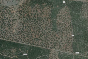
Approaches for thinning forests can result in an unnatural, systematic removal of trees, leaving a patchy or “leopard spotting” appearance when viewed from above.
Forest architecture offers several advantages over traditional methods. It enables comprehensive census-level data collection at a fraction of the cost and time, eliminates gaps in data, and provides a real-time view of the forest’s condition. The ability to visualize treatment outcomes and adjust plans accordingly ensures that management decisions align with the desired long-term vision for the forest.
“In the past, we had no idea what the outcome would look like until Google updated its imagery, and many forest restoration projects came out much different than intended, some of that resulting in an unnatural look,” Jensen says. Forest architecture eliminates this uncertainty and empowers foresters to create truly sustainable and aesthetically pleasing forests.
Looking to the Future
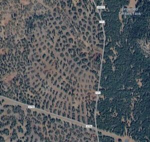
When loggers pick which trees to cut it creates an unnatural forest pattern.
Jensen envisions that as augmented reality technology matures, it will further streamline the forest management process by allowing foresters to visualize potential changes directly in the field. The combination of lidar, forest architecture, and augmented reality has the potential to transform forestry management, making it more efficient, effective, and responsive to the needs of both the environment and society.
Reality capture has proven to be an invaluable tool for forensically reconstructing past appearances and documenting present conditions. Jensen has flipped that script, bringing a fresh perspective and innovative approach to this technology.
Spending time with him in the forests of Arizona has been a powerful reminder that, all too often, we settle for the way things have always been done. However, his work and vision challenge us to rethink our methodologies and inspire us to break free from the constraints of the status quo.
By pushing boundaries and exploring new possibilities, Jensen is demonstrating that progress is made not by conforming to tradition but by daring to envision and implement change. His contributions serve as a beacon of innovation, encouraging us to continuously seek improvement and embrace the potential for transformation in every aspect of our work and lives.
Mack Kowalski has more than 10 years of experience in layout management and laser scanning to provide innovative solutions and services to our clients and partners. His passion to push the boundaries of technology and delivering high-quality results in every project led him to co-found LiDAholics consulting firm.