
The tools and resources for mapping underground infrastructure are rapidly evolving, but to keep up we must change our mindset of underground utility mapping.
The technology of underground utility mapping is on an exciting and promising trajectory. Multi-sensor approaches, even the prospect of quantum sensors, along with an explosion of phone/tablet-coupled lidar and camera sensors, digital twins, augmented- and mixed-reality platforms are all very exciting. But how do you encourage, entice, cajole, or mandate that such solutions get utilized?
In talking with Sam Wiffen, founder and CEO of Reveal, about his company’s platform that I had heard so many good things about, we turned to the motivational side of the underground challenge. This is what the late international utilities mapping advocate Geoff Zeiss was doing—inspiring and motivating practitioners, stakeholders, and policy makers to improve the state of underground mapping.
Wiffen had often exchanged ideas with Zeiss and shared many views: “I’m obsessed about the carrot of motivation as well. How do we change the culture? How do we get people to keep the records up to date? What are the motivating factors? How could we gamify it to where people are behind that? We have to start to look at humans, the way we think and operate.”
Wiffen is passionate about getting to a place where an optimal underground resource could come to fruition. He cites several key elements that would be needed, including getting the cost of capture down to where more can be done, and developing ecosystems of information that people want—and need.
 Reveal provides full services for underground utility data capture using local resources and a partner network; in the many international markets including Australasia, the U.S., and Singapore. Services then enable the management of utility data in their own platform, combining the many types and formats of data and connecting into customers’ existing asset and spatial data management systems. With the foundation of Reveal firmly rooted in geophysics and utility mapping services, the software and services are proudly driven from a deep understanding of the stakeholders and the problem.
The roadmap for the founding of Reveal and its evolution was greatly influenced by Wiffen’s own journey. New Zealand raised, Wiffen initially took up a design certificate track in his university studies but found that did not provide the science and math challenge he was seeking, so he switched his focus to engineering. At the same time, he was working in construction. “A bit of underground, large residential, and some commercial,” said Wiffen. “Project management was my forte, especially the technical elements.”
The reason he got into the underground space was that for some large projects they would find “an enormous kind of rubbish heap of redundant cables that were not on the plans. Everyone would shrug their shoulders and say ‘Oh, you know, that’s what it’s like.’ ” Wiffen has a low tolerance for the ‘that’s the way we’ve always done it’ schtick. If anything is hobbling better underground mapping, and the broader digitalization of AEC, that kind of acquiescence is the key culprit.
He started looking at progressive approaches, and what was going on in subsurface utility engineering around the world. There were two events that accelerated this process: the rebuilding of Christchurch after the 2011 earthquakes, and a national broadband rollout, for which an enormous amount of subsurface would be needed.
We’ve all experienced the pain…Things may not get built to plan, formal as-built surveys may not have been done, poorly prepared records, lost records, reliance on institutional knowledge, and legacy records are often only schematic. No amount of technological magic can take disparate, inaccurate, and inconsistent records and turn them into a digital twin.
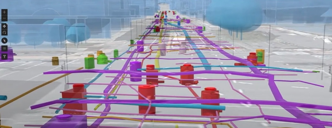
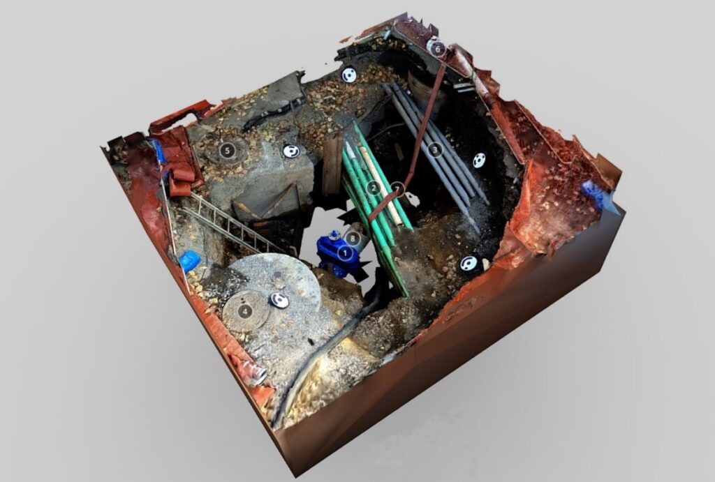
Underground infrastructure in the immersive 3D Reveal platform Credit: Reveal
There are though very effective routes to getting good, digital twin level data: proactively capturing the assets before they are buried, or with multi-sensor approaches. To the former, the disruptive tech of lidar/camera fusions, even on phones, has made it possible for an inspector to essentially “wave a phone over a trench” to get an as-built 3D model. This approach looks to be easier for new assets, however for existing assets, the only practical option is multi-sensor surveys with any sort of scale.
“When starting Reveal, my mistaken assumption was that GPR was a utility locating tool,” said Wiffen. “I was wrong. It is a geophysical instrument and best operated by a geophysicist. We sought out some young geophysicists, the most competent people we could find, to operate this equipment, and hit the market with a higher quality product.”
And it paid off. While there have been great advances in the technology, and with some solutions boasting “it creates 3D models automatically,” those who are very successful with such sensors know that the premium is still on skill and understanding the science. There is still an art to “reading the tea leaves” of GPR.
There were still challenges. “The industry just wanted the lowest price, treating the tech like a compliance box,” said Wiffen. In a way that turned out to be a good thing. While the status quo was often rough, Revel could demonstrate higher-quality mapping. “Because we’ve managed to hire and train and have onboard phenomenal people: geologists, geophysicists, geotechnical engineers, really smart people who understand this and could really challenge and would understand what they’re getting from radargrams. We started to really push and improve our quality and get into the utility mapping components.”
The value they were able to demonstrate to contractors, who had previously been used to sketchy records, minimal-locate-tech paint marks, weighing the risk of uncertainty and deciding to pothole anyhow, was high confidence.
“The first thing I say to these companies is: ‘you need to stop the leak in the ship,’” said Wiffen. “Any information that comes in, you have to form a new strategy for what this information looks like. And then we can start to reconcile the existing assets to conform to that, because otherwise, we’re just not making any progress.” There was a lot of resistance to changing the back ends; the disconnects between large entities and their data silos.