Category Archives: Surveying

7 Gifts under $70 for Surveyors
I’ve put together this year’s list of gifts with practical ideas that any field surveyor should find useful. All prices are accurate at the time of writing; I’m not responsible for price hikes. All items are highly rated (four- to five-star online reviews), but use your best judgement) 1) Yeti Loadout Bucket. Five-gallon buckets are...
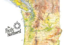
The Pacific Northwest
Maps as Art These earth-toned watercolors reflect the greens, browns, yellows, and blues of the verdant Pacific Northwest. I spent hours comparing source material and drawing and re-drawing this map, so I have a new depth of admiration for the mapmakers of old who pioneered this exacting business. I begin every map with a 1″...

A Silver Survey in My Golden Years
This summer I had the joy of experiencing the best boundary retracement “job” of my 40-year surveying career, and it came about quite by accident. For most of my life I’ve had the privilege of visiting a cabin on the eastern side of the Sierra Nevada Mountains owned by the family of a childhood friend....

2022: Monumental Changes, Part 1
The National Geodetic Survey of the U.S. responds to surveyors’ questions on how legacy physical geodetic monuments will be affected by the planned 2022 reference framework modernization. Editor’s note: A recent article in xyHt’s online newsletter, Field Notes, prompted a discussion among surveyors on the pending 2022 modernization of the National Spatial Reference System (NSRS) for...

2022 and You
The year 2022 …. “And then one day you find ten years have got behind you. No one told you when to run; you missed the starting gun.” —Time, by Pink Floyd (Gilmour, Wright) The year of the planned update of the U.S. national spatial reference system, 2022, looms large on the horizon and is...

Protecting Your Eyesight – at Your Desk
I use special glasses to reduce eye strain in my screen-centric workplace. The geospatial industry has evolved greatly over the last decade, and with the current evolution of our systems this trend shows no sign of slowing down. We are seeing more and more of what has traditionally been considered fieldwork being brought into the...