Category Archives: Surveying

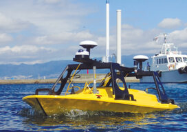
AUVs: Crucial to Seafloor Mapping Effort
In 1775, in Saybrook, Connecticut, the brothers David and Ezra Bushnell built Turtle, a little egg-shaped wooden submarine held together by iron straps, with a 30-minute air supply. The next year, in New York Harbor, Turtle engaged in the first naval battle in history involving a submarine. The first autonomous underwater vehicles (AUVs), undersea systems...
All Hands on Deck
Mapping the entire U.S. seafloor is an epic task. The country’s new national hydrographer says it can be achieved by coordinating efforts and using the latest technology.
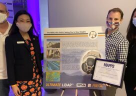
MAPPS 2020 Geospatial Excellence Awards
MAPPS honored members with the 2020 Geospatial Excellence Awards as part of the organization’s 14th annual Awards Presentation that took place January 26, 2021. The event was hosted by Riegl USA in conjunction with the 2021 winter meeting in Orlando, Florida. The Geospatial Excellence Awards are presented to regular and associate member firms whose entries...

A Profit Without Honor
While easements are often treated as the 'poor relations' of property rights, the 'Profit a Prendre' often seems a mere afterthought by courts.

The Incredible Journey
As 2021 begins, I am certain we all look back at 2020 as a year unlike any other in our lifetimes, likely not in a positive way. Even without the crushing pandemic, last year has been a stressful challenge on many fronts; heightened civil unrest, an extremely polarizing election, and the San Francisco 49ers losing...

Expand Your Horizons, by Measuring Water Boundaries
If you are like the average Professional Land Surveyor, your practice area has been in a certain sub-specialty such as land boundaries, construction stakeout, or topographic mapping for years or decades. Water boundaries? Not so much. You are very good at what you do, enjoy it, and have built a profitable niche in your community....