Category Archives: Surveying

Yost: The Host with the Most
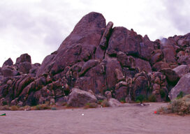
When I was a young party chief with a firm in Hagerstown, Maryland, in 1982, we were contracted to survey a tract of mountain land for a man named Yost. He was convinced that he owned much more land than his deed specified. When my co-worker and I visited the site and met with the...
2021 NSPS Student Competition
The 2021 NSPS Student Competition will be held in conjunction with the Spring meetings of the National Society of Professional Surveyors. This year’s competition will not include field exercises in order to accommodate official health and safety advice. The Competition will begin with an online briefing event on February 16, 2021 with a presentation by NSPS of...

The Challenges of Near-shore Hydrographic Surveys
Near-shore hydrographic surveying can be a challenging task, especially if the conditions are not ideal to collect the required data.

Digitizing America’s Coast
Legislation passed by congress and signed by the president codifies NOAA’s exemplary digital coast program Geospatial professionals and coastal communities are celebrating the passage of the Digital Coast Act (DCA) by remembering the coordinated efforts from the numerous public and private stakeholders that were necessary to help pass this important legislation. The intent of this...
The Early Days of 3D Scanning: Part 8
In multiple ways, 1999 turned out to be a pivotal year for Cyra Technologies and for 3D laser scanning, in general.

senseFly Expands its Line of Fixed-Wing Mapping Drones
A mapping drone in the $10,000 price range might sound like one of those things that’s too good to be true. And up until now, maybe it was. A Swiss company called senseFly, a global leader in fixed-wing mapping drones, has expanded its flagship eBee X drone solution with the launch of eBee Geo. The...