Category Archives: Surveying

Mapping the Appalachian Trail, Part 2
How the AT was brought into GIS via a collaboration among ATC staff, NSP professionals, and dedicated volunteers. Part 1 of this article (May 2015) reveals the history of the trail, particularly how the land that comprises it was surveyed. Read here about how the trail was brought into GIS. In 1998, the Appalachian Trail...

Stockpile Reports
How to do enterprise inventory management from image-based 3D reconstruction, in the cloud and in your pocket. “No one wakes up in the morning thinking that they need to buy a point cloud,” says URC Ventures CEO David Boardman. “Most people would be thinking that they need to solve some business problem.” What URC Ventures...

Summertime, and the Surveying Ain’t Easy
Now that winter and even spring have finished thrashing half the country, we can officially enjoy summer. As a laser scanner operator I have a fairly easy job this season due to the limitations of the instrument—at least, it’s easier than being a field surveyor. If you’ve ever worked on a survey crew in the...
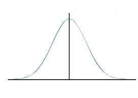
Surveying Statistics
Part 2: The Normal Distribution Part 1 of this series appeared in the May 2015 issue. Errors in observations can be classified as systematic or random. Systematic errors follow physical laws and can be mathematically corrected or removed by following proper field procedures with instruments. For example, the expansion or contraction of a steel tape...
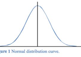
The Normal Distribution, Part 1
Errors in observations can be classified as systematic or random. Systematic errors are errors that follow physical laws and can be mathematically corrected or removed by following proper field procedures with instruments. For example, the expansion or contraction of a steel tape caused by temperatures that differ from the tape’s standard temperature is a systematic...

Creating Energy From Images
Geospatial information has long played an essential role in the energy industry, but now a new technology is cutting costs while improving the flow of knowledge. Editor’s note: The energy sector, oil and gas in particular, has grown more rapidly in the past half dozen years than in the past half a century. New fields,...