Category Archives: Surveying

Raising the Roof
A survey company changes its tactics to monitor an auditorium roof before, during, and after its lift into place, using teamwork and true professionalism. American Surveying & Engineering, P.C. (with corporate headquarters in Chicago, Illinois) was approached by JP Cullen (a contractor with headquarters in Janesville, Wisconsin) with a challenging project: a particularly tricky auditorium...

Capturing the Wind
A one-person crew provides foundational data for building a massive wind farm in Australia, using integrated survey technology. When you look at the commanding stature and aesthetically pleasing symmetry of the turbine towers at the Mt Mercer Wind Farm in southeast Australia, it is easy to gloss over the central role that surveying and engineering...
Geospatial PPPs
Striking the right balance in building national cadasters with private/public partnerships. Land ownership is a foundation of national economies: those who have land titles can use them to obtain credit (which is often essential to start and expand businesses), and property taxes are a key source of government funding. Therefore, authoritative and efficient land registries...
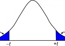
Surveying Statistics
The t Distribution, Part 2 In the previous article (July 2015), I introduce the concept of sampling distributions and the need to use these distributions to analyze small samples of data. In surveying, observing small samples is typical where angles are often observed only two or four times, and repeated distance observations simply means pushing...
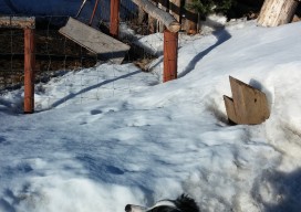
The Two Fences
Surveyor Igor Kidinsky, alias Eager (The Kid), could not seem to fit the fence with his calculated property corner. His calculations kept leading him to the other fence, a few feet away. Glenny Dale, alias Glutton (The Old Man), looked on, struggling to convince his logical mind that there should be two fence lines here...
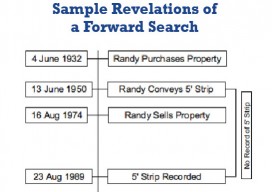
Survey Law
Seniority of Title and Forward Search I am often a part of litigation involving surveying services and research mistakes. (I must admit that, in excess of forty years of practice, I have made my share of mistakes performing record research.) I’ve observed five common research mistakes often made by surveyors. This article explains the common...