Category Archives: Surveying

SHS 2015 Rendezvous
This past September, surveyors gathered to learn about and participate in the history of the Washington/Canadian border and the San Juan Islands. It was a fun and exciting time this year at the Surveyors’ Historical Society’s (SHS) annual rendezvous. Amidst the beautiful scenery of Washington State, surveyors from all around the country gathered for a...

Sampling Statistics
The Chi-squared Distribution In my most recent article (August 2015), I discuss Student’s t distribution and how its properties can be used to isolate blunders in observations. Another sampling distribution that is commonly used in least squares adjustments is the χ2 (chi-squared) distribution. It appears in the form of what is typically called the “goodness of fit”...
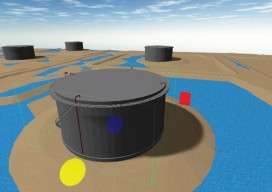
True 3D Design
New geospatial software combines the appeal of games with the rigor of applications. It’s never been done before: applying the rigor and disciplines of civil engineering, mining engineering, hydrology, and even classic survey field-to-finish to game-like 3D design. Sure, CAD operators have had 3D viewing for years, which they use to review the results of...

Blending Realities
A 3D design and visualization tool with phenomenal potential in the AEC world is coming from a collaboration between Microsoft and Trimble. Imagine designing an object, in 3D and color, using only gaze, gestures, and voice (GGV) commands. Imagine designing an entire building the same way—or modifying an existing one. Imagine moving in a physical...

Fundamentals of Geodesy
Part 1: An Introduction Editor’s note: With this article we start an overview of GeoLearn courses offered by Dave Doyle, former chief geodetic surveyor for the National Geodetic Survey and geodesy editor of xyHt. GeoLearn (geo-learn.com) is an online education business helping professionals reach mandatory continuing education requirements and sort through everyday work issues. Dave’s...

The Record 1/16 Corner
Glenny Dale (The Old Man), picked his way slowly through the pines, looking down and left and right, trying to remember where the old pipe was. Two Steller’s Jays perched on a pine branch directly above. One of them blended into the deep blue sky, the other into the black pine shadows. Their slightest flicker...