Category Archives: Surveying

Carlson’s BRx5 Receiver: the Birth of a New Instrument
Carlson Software & Hemisphere GNSS Bring a Lightweight Receiver to Market For land surveyors and others in careers that rely on constant use of GPS and GNSS technology, not to mention the millions of consumers with receivers in their smart phones, it is easy to forget that instant location remains technologically miraculous, relying as it...

Trimble Unveils SX10 Scanning Total Station
Trimble unveiled a next-generation survey instrument—the Trimble® SX10 Scanning Total Station. It merges high-speed 3D scanning, enhanced Trimble VISION™ imaging technology and high-accuracy total station measurements into familiar field and office workflows for surveyors. The innovative solution provides surveyors and geospatial professionals with the capabilities and versatility to handle projects from traditional surveys to complex...

A New High-rise Squeezes in, Thanks to a Total Station
A Hilton complex requires survey technology to ensure its place among historic buildings in Norfolk, Virginia. Norfolk, Virginia, has a history of adapting to change. (Above: Norfolk’s newest high-rise was engineered to fit into its urban footprint.) With beginnings in 1636, the city has undergone war, epidemics, fires, and economic depression to grow into the...

Using OSTN15 with QGIS
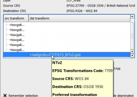
As you may be aware, the United Kingdom has a new transformation model that is OSTN15. But why? What does it mean to the geospatial community? Without being too nerdy, tectonic plate movement means that the “model” surface (the geoid) is slowly moving away from being the best fit for the coordinate system. It has...

Methods of Analyzing Data, Part 1
Identifying Blunders with Graphics Mistakes and blunders are an inevitable part of being human. In fact, a wise person once told me that the only people who don’t make mistakes are those who don’t do anything. Because a least squares adjustment of a plane survey is nonlinear, it will not arrive at a solution if...

Action Plans: Forum on the Future of Surveying
The second meeting of the Forum on the Future of Surveying produced a plan of action and strategy. Editor’s note: This column continues to provide monthly coverage of the national initiative, Forum on the Future of Surveying (FFOS). See the first installment in our March issue. The goals of the second meeting of the Forum...
