Category Archives: Spatial IT/GIS

Ordnance Survey go GovCo
A new model for operation of The Ordnance Survey of the UK has been announced. This looks promising for the future of the customer and it is good to note the reference(s) to the use of the term “Open & free where possible”. It certainly looks like there are some exciting times ahead for the...

CLIVE: Communicating Risk in 3D
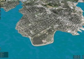
Above: The current sea level and coastline of the city of Charlottetown on Prince Edward Island, Canada. Static 3D models of topography and buildings are commonplace in both technical and popular geospatial software. There are still very few 3D tools, however, that enable users to geo-visualize dynamic phenomena, such as the effects of climate...

Call for Abstracts for 2015 GIS in Action!
Mark your calendars for May 4-6, 2015 and join us in Vancouver, WA at the Hilton Vancouver Hotel and Conference Center for the 2015 GIS in Action conference. This year’s conference is jointly sponsored by the Oregon-Southwest Washington Chapter of URISA (ORURISA), Washington State Chapter of URISA (WAURISA), and the Columbia River chapter of ASPRS...

Going Smaller to Grow Bigger
Editor’s note: Some of the more significant changes in workflows and data management in surveying field and office operations have come in recent years: a move to mobile, robotics, and cloud-enabled software suites. But, how has implementation played out? We offer the following case study of a forward-thinking surveying and mapping firm that has implemented...

Fighting Crime with GIS and Lidar
In spring 2013, the Bureau of Alcohol, Tobacco, Firearms, and Explosives (ATF) needed to track and apprehend major targeted offenders in Weakley County, Tennessee. They asked the county 911 department to assist in creating GIS-based intelligence packages to be used as a critical tool for this job. This request, plus an increased demand for more...

Creating the Futuristic Worlds of 3D
We interviewed Autodesk’s technology futurist Jordan Brandt, appropriately, in the Autodesk Gallery at their One Market offices in San Francisco. The Gallery, open to the public and the venue for monthly techie events, is a showcase for eye-popping examples of the types of innovation Autodesk’s customers have been producing for more than three decades. It...
