Category Archives: Spatial IT/GIS

Internet of Things
Above: IoT has gone open-source: the Spark Core is an affordable ($39) device that lets anyone connect nearly any device via WiFi to the internet. All components and developer software are open-source. Innovative Power for Sensors, Richer Data It has been a great year for the tech industry and especially for the Internet of Things (IoT),...
3D GIS
Breaking the Wall between Consumer and Professional, the Appearance of Disappearance, Versioning An Interview with Lawrie Jordon Contrary to what the current buzz might indicate, GIS and CAD have been 3D-rich from their start (although sometimes with elevation as an attribute, not necessarily part of the core spatial definition). Even in the 1990s era of...

QGIS v ArcGIS
Okay, so I’m likely to get lynched, but before all the lovers/haters come out of the woodwork I’d like to remind everyone that these two systems are both great achievements. We are looking at two software systems that have changed the way we look at the world and the way we think about the world...

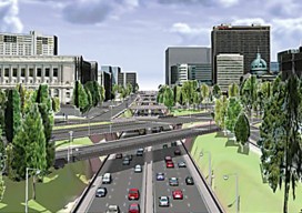
Transportation
Traffic Analysis in Real Time Until recently, geospatial experts have been unable to truly record traffic data because there hasn’t been a way to get a near-perfect record of traffic data at the lane level. Yet, it’s more evident now than ever that the need for near-perfect data is becoming a critical requirement for the...

Geographers’ Tour – On Intersections: Vancouver
A comment came by on Twitter recently saying, “Geographers always want window seats on planes and trains,” and it was a big Favorite. We understood because geographers are living spatial scanning machines, a constantly analyzing nexus of the places, spaces, connections, patterns, and relationships that surround them. Thriving on constant extrinsic access to the world,...

Hypervoice
Rendering 4D Sensed Environments In the world of personal communications, the white-hot winds of change shimmer, blurring the present and obscuring our view into tomorrow. We are in the midst of a massive revolution, blasting away much that went before it. It can best be summed up like this: the future is all about ubiquitous...