Category Archives: Spatial IT/GIS
Alasdair Begley
Alasdair Begley – Director – Saunders Havill Group – Australia Alasdair Begley views the design and development of commercial and public projects in a holistic manner and develops solutions to challenges— approaching each as integral parts of the design process rather than compartmentalized independent tasks. And with his bachelor’s degree in surveying from the Queensland University of...
Morgan Ré
Morgan Ré – High school student intern at NASA – Virginia, USA Morgan Ré attends both governor’s school and high school in Virginia; she’s on track to graduate with an associate’s degree in May before graduating high school in June 2015. She’s been interested in working for NASA since sophomore year when she began at Virginia...
Lily and Sarah Jenkins
Sarah and Lily Jenkins – Student Science Award Winners at Molokai High School – Hawaii, USA Featured in the keynote address of the 2015 Esri user conference were high-school siblings Sarah and Lily Jenkins. Their team won an international science competition for their geospatial analysis of the “March of the Molokai Mangrove” on how the invasive non-native...
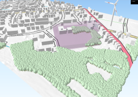
Further Adventures with 3D GIS
Last year I posted about this awesome plugin called “QGIS2Threejs” [here] and how it was possible to quickly render 3D visualisations for free using the open source GIS, QGIS. At the time I fudged some wind turbines as it was impossible to import models. Furthermore, I avoided too much detail as any imagery would look...
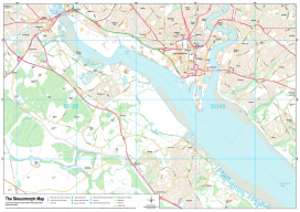
Recreating the Ordnance Survey Explorer Maps with Open Data
The holy grail for many (UK) map users is the Ordnance Survey 1:25,000 scale “Explorer” map. Not only are they easy to read due to the fantastic cartography used, but they also have information which is hard to source such as public rights of way, National Trust & Woodland Trust sites, even wind farms. To...
Why Your Maps Should Get in Touch with Their Feminine Side
Google does it, Apple does it, but do your maps use landmarks to improve users’ familiarity? More to the point, why aren’t popular landmarks a standard GIS dataset? For more than 10 years now we’ve known that the majority of the population use spatial recognition to navigate. When I say “majority.” I mean women and...