Category Archives: Spatial IT/GIS

The (Android) Empire Strikes Back: Mainstreaming Augmented Reality, Part 2
Let’s pick up the AR thread again and look at what the Android platform has to offer in augmented reality (AR). It was just a matter of days after Apple rolled out its ARKit SDK (software development kit) when Google followed suit with its ARCore SDK. ARCore is built on Tango technology but expands the...
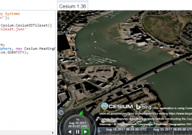
Add 3D Tiles to Cesium 1.36 to Make 3D Virtual Scenes
As blogs come, this has to be (for me) one of the longest. You see, I’ve been playing with Cesiumjs since its beginning and following the exciting beginnings of the “3D Tile” for the last 3 years. I’ve waited patiently, waiting for the moment I could share with the world how fantastic this new technology...

Night in the Afternoon: A US Solar Eclipse
What you need to know about the 2017 solar eclipse The upcoming solar eclipse will leave a 70-mile-wide trail of darkness across the United States on August 21, 2017 (see the map of the eclipse path on pages 44-45). This will be a once-in-a-lifetime event for many people. While another total solar eclipse will make...

A Good Day with a Bad Elf
It was a beautiful early summer day, ideal weather to take a road trip to the Pike National Forest about an hour from my Eastern Colorado home. Pike National Forest comprises 1,106,604 acres southwest of Denver and is a frequent haunt of mine for camping, off-roading, and in past years dirt biking and ATV-ing. This...
Multipurpose GIS with ArcGIS Pro
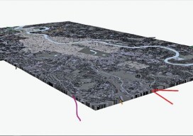
You can now use point clouds and massive geospatial data with GIS through the web and your desktop with new software. Above: London rendered in 3D with London Underground data. For years, point clouds (lidar, laserscan, and multibeam) have been pretty useless to GIS users. When a GIS user had to analyze the data, often...

Free GIS Training
The ABCs of GIS via MOOC Massive open online courses (MOOCs) provide an affordable (generally free) and flexible way to learn new skills to advance or enhance your career or for your own personal development. The team over at Esri has joined the MOOC movement with five free GIS-related courses that require only a few...