Category Archives: Spatial IT/GIS

Geospatial Data United
Industry trends are moving toward consolidated environments for data visualization, processing, and management. From the title you might get the impression this article is about a soccer team. To geospatial professionals, however, the title phrase could describe an ideal situation—the ability to handle all geospatial data in a common software environment. A soccer team is made up...

Virtualization: the Greatest Tool You Don’t (Currently) Use
This post is dedicated to a good friend, Chris Johnson, who, when we worked together a few years back, introduced me to this cool new word: VIRTUALIZATION. You see, Chris is an IT guru (see: enterprise systems architect)—a friend that every GIS guru should have so that you’ve got someone to pick up the pieces...
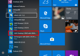
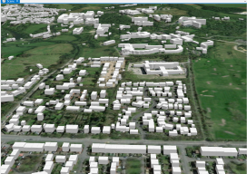
How to Use the New QGIS 3D
When QGIS revealed that they were going to add a 3D viewer, I was skeptical. Rumors were going around about it being a bolt on functionality and not really being fully adopted. To be perfectly honest, I was put off before there was anything to look at. As screenshots started to appear from Lutra Consulting,...

The Problem with GIS and Augmented, Virtual, and Mixed Reality
Over the last few years, altered realities technology has exploded, and now, with the introduction of Apple’s ARKit and Android’s ARCore, AR, MR, and VR are well within the reach of the non-developer. I can confirm this as I’ve created a few AR apps and MR apps myself over the last few months, with no experience...
Making Heightmaps
There is no hiding it: I’ve been building a lot of 3D data recently, partly to sell, partly to fuel my adventures into augmented reality (if you’re interested in me adding this to the blog, please say!). The main vital thing has been the heightmap. Providing Certainty in 3D Heights What is a heightmap, you...
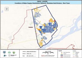
SWAMS
Using GIS for utility asset management: the Water Supply Asset Management System The cost of maintaining water system utilities is a concern of all responsible administrative authorities. And utilities are assets that need to be sustained rather than replaced again and again to provide people with quality service. Therefore, better asset management is needed; without...