Category Archives: Spatial IT/GIS

Ainura Temirova
Post-graduate Geomatics Student, University of Glasgow Kazakhstan The large, beautiful, and resource-rich central Asian country of Kazakhstan is the home of Ainura Temirova and where she began her quest for a career in geography. Her studies began at Eurasian National University, the premier technical university in the region, and she began working for the Geotechnical...
Belinda Serafin
Graduate Surveyor, Sydney Trains Australia Sydney Trains is the premier public transportation system for this city of more than four million. With infrastructure serving more than 340 million rider trips per year, the maintenance, upgrade, expansion, monitoring, and mapping for properties, planning, and environmental matters require a top surveying team. In 2017, a new graduate...
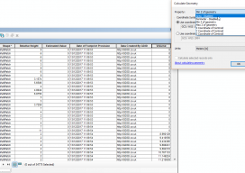
Calculating Geometry outside ArcGIS Pro
Let’s be clear: this isn’t a stab at the all-new, singing and dancing Esri software. This post is meant to help those who are using the software on a regular basis but finding issues with using the fields with multipatch data. Recently I’ve been working with calculating volumes of buildings that are multipatch data. For...

Data for Slums – A geospatial analysis of living conditions of the Pakistani poor helps to improve them.
The tendency for cities is to grow: spatially, by population, or both, and in Pakistan’s capital of Lahore, it’s been both. Urban growth leads to uncontrolled population and unplanned areas, usually along the edges of cities. Rapid urban population growth has outpaced the ability of city authorities to provide housing, environmental protections, and health infrastructure....
Savanna Nagorski
Assistant Planner/GIS Analyst, ESM Consulting Engineers Washington, USA Although Savanna Nagorski has only recently begun her work with a prominent consulting engineering firm in the Pacific Northwest, many people have recognized her potential and predict a bright future. Savannah distinguished herself in stints as the GIS coordinator for the Tacoma campus of the University of...

Siddharth Pandey
Assistant Production Manager and Senior Geospatial Analyst, Dewberry, Virginia, USA A mentor, a master’s student in GIS, a geospatial practitioner, a leader in professional associations, and an advocate of the geospatial industry, Siddharth “Sid” Pandey works hard, promotes the geospatial industry and its capabilities, and is a vital team player, lifting others up and always offering...