Category Archives: Spatial IT/GIS
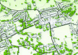
QGIS Details
How features are developed, plus details on releases, support, and plugins. Editor’s note: Tim Sutton has been a figurehead for free and open source software (FOSS), is past chair of the QGIS steering committee and is also co-owner of Kartoza. Here he kindly writes about how QGIS works on a project level from his vast...
Founder of QGIS: Gary Sherman
An Interview with Gary Sherman If Roger Tomlinson is considered the father of GIS, then Gary Sherman is one of the godfathers. He started building a GIS to solve a particular problem, and it has since grown into the world’s most-popular free GIS: QGIS. Gary doesn’t often give interviews, so when he agreed to do...
QGIS: What Is It and How Does It Work?
Editor’s Note: Nowadays everything costs, whether you are a solo practitioner, in a small business, or part of a large firm seeking to expand. You buy a new laptop, you need an operating system, then office software, then a broadband subscription; the cost keeps escalating. Are you bound to this legacy progression of costs? Not...
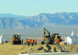
What Can Spatial IT Do for You?
Helping firms meet the challenges of the global uptick in infrastructure development. Editor’s note: What is spatial IT? This umbrella term for the spatial component of the new wave of digital wizardry that’s transforming our geospatial and geomatics professions and industries can seem nebulous. xyHt has adopted the following working definition (as the term applies...
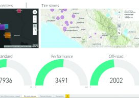
mESRIsoft
More than partners, Esri and Microsoft collaborate and combine platforms to benefit their users and the public. From their CEOs, Jack Dangermond and Satya Nadella, down to the individual developers and field sellers, Esri and Microsoft work together very closely. “We are connected at almost every level to each other’s companies,” says Lea Ann Thurman,...

My First Trip to the Esri UC
No matter what flavor of GIS you roll, there is no ignoring the annual Esri user conference in San Diego. The highlight is the opening plenary session which is always given by the (co) founder of Esri, none other than Jack Dangermond. To discuss this fully, we have to start at the beginning, which was...