Category Archives: Spatial IT/GIS
Creating Album Covers with GIS—or Drawing Elevation as Vector Lines
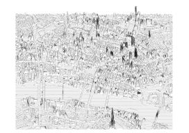
In July 2014, a developer and neocartographer from Scotland created the “Joy Divionesque 3D Map.” This began a four-year onslaught of maps that replicate the style of the iconic Joy Division album cover, “Unknown Pleasures.” How does it work? Essentially the elevation is taken from an underlying terrain or digital surface map as points, which...

CA Wildfire Cleanup
The U.S. Army Corps of Engineers, under the direction of FEMA and in partnership with the California Governor’s Office of Emergency Services, removed more than one million tons of fire-related debris. Credit: Carol Vernon, Public Affairs, Pittsburgh District, USACE. The U.S. Army Corps helps rebuild lives with GIS technology. In October of 2017, numerous, fast-moving...

GIS Day
From the Coordinated Campus In a rapidly changing field such as geotechnologies, education is an ongoing concern and rightly so: if we are not lifelong learners, we won’t last long in this industry. But I contend that we as geospatial professionals also need to be aware of and provide leadership in larger geospatial education trends...

Interview with Esri’s John Nelson
A few years ago, John Nelson was relatively unknown in the public eye, but in the last year he has gained attention through work he’s been doing with Esri GIS software. Who would have thought you could recreate the Lord of the Rings maps or simulate paper or watercolors using Esri GIS? Theses are just...

Esri – Autodesk Partnership
Year one of a bold partnership—that the world of infrastructure really needed to happen. Geospatial Giants Esri president and co-founder Jack Dangermond and Autodesk CEO Andrew Anagnost both agreed to our interview request to provide insights on the Esri-Autodesk partnership, now entering its second year. Of course, they discussed the specific fruits of the collaboration...

Interview with Esri’s Chris Andrews
When I knew that I was going to the Esri User Conference, I asked a few friends at Esri to find out who could tell me what super cool stuff was coming up in the platform. One name came up over and over: Chris Andrews, senior product manager for 3D. For those who haven’t heard...