Category Archives: Spatial IT/GIS
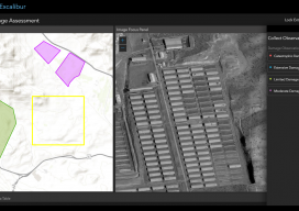
ArcGIS Excalibur
A new “un-GIS” GIS tool enables access, measurement, analysis, and markup capabilities for images – for everyone. Many years ago, during the era of cinematography and good old-fashioned film, they used to edit movies by cutting the film with a pair of 9-inch scissors; these were called “excalibur.” This sets the scene for the new...
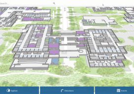
ArcGIS Indoors
What is it, and how will it work? Mapping has traditionally been the task of visually charting big outdoor spaces with pretty hills that look great with a few contours around them. Throw in a bit of hillshade, and you have a cartophile’s dream. The location intelligence company Esri, that has driven the market to...
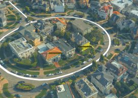
Embrace the Mesh
Above: A full 3D textured model of San Francisco produced through Skyline’s PhotoMesh 3D Reconstruction software and streamed for visualization and analytics in Skyline’s TerraExplorer. Surveyors and photogrammetrists capture reality data. But to model, manage, and provide access to massive and complex datasets—to provide your clients with true 3D mesh reality capture—you’re going to need...

In the Blink of an AI
If we were to believe Steven Spielberg’s version of the future, curiously, robots can’t blink. It seems like mechas, as the life-like robots in his movie AI: Artificial Intelligence are called, lack the AI codes to involuntarily close and open their mechanical eyelids. Notice how almost all robots in Hollywood movies follow the same no-blinking pattern. Watch The Terminator movies, if you don’t...

Ocean Business 2019
With preliminary surveys already starting around the coast of the UK for another round of wind farms being built, the offshore industry descended on the National Oceanographic Centre in Southampton, UK for the bi-annual event, Ocean Business, centered around the offshore survey industry. Luckily, my home is a walk away from the event, so I was more than happy...
Geospatial World Forum 2019
At the GFW19, the geospatial industry, community, and professions find common ground to promote geo-business, to showcase innovation, and to collaborate to seek solutions for global issues. I’d like to emphasize the word “forum.” The Geospatial World Forum 2019 (GWF2019), held in April in Amsterdam, holds a special distinction and role in the global geospatial...