Category Archives: Spatial IT/GIS

Unity Reveals Reflect
Reflect by Unity is like … the gamification of BIM? Imagine you get an email message that reads, “We’re reviewing the Alderson building model. See you in 10 mins?” Seeing this, you take a large slurp of hazelnut latte and put on your VR goggles and hand grips. Suddenly, you are transported (digitally) inside a...
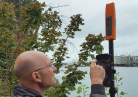
Flex! Bad Elf and Higher Precision
I took a new GPS mapping receiver out to the field for a test drive and found out that it is also a full GNSS survey rover. GNSS mapping peripheral-maker Bad Elf recently introduced a full survey-grade rover—and a unique pricing model. Surveyors might not be familiar with the name Bad Elf, but in the...
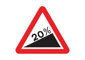
Using Real Road Signs in GIS
At the moment, I am doing a little work with the construction industry that requires road signs and markings placed on a map to show where signs need to move as the site(s) moves through different phases. Now, a real cartographer nerd would say that good graphics and symbolization would negate the need for placing...
What Is PostGIS Day?
For the last 20 years, we have celebrated GIS day along with Esri. It is a great opportunity to get people who haven’t used GIS or mapping before in your office to have a look at what you do and maybe share a map cake (Note: It is traditional for GIS professionals to make a...

AEC Plus GIS
Above: You can connect to Esri’s ArcGIS directly from inside Autodesk’s Civil 3D. The Autodesk-Esri collaboration continues to lead the way in AEC+GIS with the announcement of significant, direct—and lateral—developments. Now entering its third year, the Esri-Autodesk collaboration launched in 2017 with great enthusiasm, as many practitioners in respective disciplines had been struggling with legacy...

Mandatory Drone Registration for the UK Looms
Operator ID Is Coming to the UK (Above is the mdMapper3000DµoG from Microdrones.) In the UK, starting November 30th, it will be mandatory for all drone owners [and model aircraft owners of drones/planes weighing more than 250g (8.8oz) up to 20kg (44lbs)] to register their details with the CAA (this is called an OperatorID). Owners of...