Category Archives: Spatial IT/GIS

Saving the Big Cats with GIS
Location intelligence is helping livestock herders and lions peacefully share the land in Africa

When Mapping Goes Viral
Digital mapping has boomed during the COVID-19 pandemic. From tracking cases to allocating vaccines, GIS technology is at the frontline of the war to beat the virus.

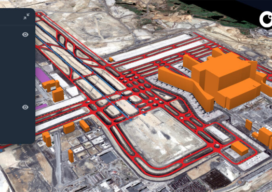
Creative Uses of 3D Modeling
The 3D data collected with laser scanners and digital cameras can be used to create digital and physical 3D models that have myriad applications—from marketing a new building to routing first responders in an emergency.

GNSS rover developments give surveyors a new edge
Chris Trevillian describes the Trimble R12i GNSS receiver with ProPoint engine with tilt compensation and calibration-free operation for flexibility, traceability and robustness
GIS Implementation in Construction: Techniques and Benefits
With Aspectum mapping software, construction companies can model objects down to the finest details and monitor project development from start to finish.

senseFly Expands its Line of Fixed-Wing Mapping Drones
A mapping drone in the $10,000 price range might sound like one of those things that’s too good to be true. And up until now, maybe it was. A Swiss company called senseFly, a global leader in fixed-wing mapping drones, has expanded its flagship eBee X drone solution with the launch of eBee Geo. The...