Category Archives: Spatial IT/GIS

How Deep Learning For Remote Sensing Produces Quicker, Higher-Quality Results
As the volume, velocity, and variety of the data generated to address worldwide geospatial needs has steadily grown, advances in the systems and algorithms needed to produce spatial and temporal resolution data have not kept pace.

The Growing Use of Drones… In Crime Scene Investigation
With the sky darkening over an empty parking lot by the railroad tracks in Las Vegas, Nevada, the group of law enforcement professionals leaned in to hear Douglas Spotted Eagle, founder and director of educational programming at Sundance Media Group and a well-known industry figure, explain how drones would be used to capture the simulated...

NSPS, Geospatial Firms and Others Support IIJA
In a letter to U.S. senators, the National Society of Professional Surveyors, geospatial firms, AEC firms, and transportation entities urged all senators to support the Infrastructure Investment and Jobs Act (IIJA), saying it will “provide meaningful economic and quality of life enhancements to communities across the country.” In all, 76 firms urged passage of the...
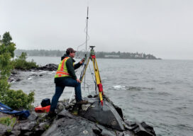
Teaching the Future
A small university on Michigan’s Upper Peninsula is educating the next generation of surveyors and geospatial engineers

xyHt Weekly News Recap: 07/16/2021
Esri Releases New Predictive 2050 Global Land Cover Map Esri Awards GIS Users for Innovations Velodyne Lidar Partners with NVIDIA Metropolis for Infrastructure Solutions Zoom75 & Zoom 95 – The New GeoMax Robotic Total Stations Lidar Helps Reveal Radiation Hot Spots at Chernobyl GIS-Pro 2021: October 3-6, 2021 Setting the Record Straight: The RETAIN Act...

Surveying and GIS: It’s ‘And’, not ‘Or’
When I graduated from college several decades ago, a retiring drafting professor said to me, “The things that are going to change during your career are difficult to comprehend. I wish I was going to be around to be part of it.”