Category Archives: Spatial IT/GIS
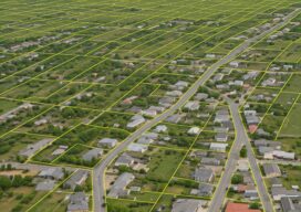
Advancements in Parcel Mapping Tools – Part 1
Whether a parcel map is created for an engineering project, land development, valuation, tax assessment, land administration and management, for a subdivision, city, county, or whole country, the tools to create and manage them have dramatically improved.
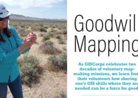
Goodwill Mapping
As GISCorps celebrates two decades of voluntary map-making missions, we learn from their volunteers how sharing one’s GIS skills where they are needed can be a force for good.

The Future of Geospatial Data Demands a New Approach to Management
Geospatial data serves as the foundation for many mission-critical and time-sensitive applications, including Earth observation, location-based services, defense, population health, and more. However, geospatial data is not just one thing and can be quite heterogeneous, coming in many different forms including point clouds (e.g., lidar and sonar); polygons (e.g. buildings and areas of interest), and...

Better Wine with GIS
One of the best vineyards in the world receives care and correction guided by smart maps

Signed, Sealed, and Delivered
From GIS to satellite remote sensing and street-level imaging, the latest geospatial technologies are behind every successful delivery, down to the very last mile.
This is GIS
As the leading professional organization for GIS professionals, URISA has long supported climate and community resilience efforts. The association has delivered 20 years of GIS emergency management and response and resilience efforts across the globe through GISCorps, to leading development and supporting sustainability and community resilience data efforts, conference sessions, training, and workshops and with...