Category Archives: Lidar/Imaging

Learning to Scan
An interior scan of an auditorium by undergraduate students gave them a thorough lesson. Florida Atlantic University (FAU) is the only school in the southeast that offers geomatics engineering, and the professor for the terrestrial laser scanning class, Dr. Sudhagar Nagarajan, asks a lot of his students to succeed. During this past spring semester (2018), we students had...

Cool Stuff Seen at HxGN LIVE 2018
Juergen Dold, president of Hexagon’s geosystems division, walked onstage to deliver his annual keynote at the 2018 HxGN LIVE conference and exhibition, toting a small school-sized backpack. During the course of the keynote he pulled two new products from the backpack. BLK3D The first was the BLK3D, a pocket-sized 3D measurement device built for rapid...

Not Everything Requires High Accuracies
How feature inspection, assessment, and reporting are now available to non-experts (and experts alike). In the early 2000s, Leon Toorenburg was in Africa mapping the locations of communications and utility towers. He was carrying a laser range finder, a camera, a GPS receiver, a laptop, and a field stick. It occurred to him that there...
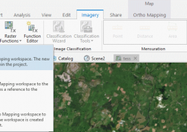
Using Ortho Imagery (Digital Aerial) in ArcGIS Pro
The new version of Esri’s ArcGIS Pro software offers the capability to use stereo imagery, something of great use to those looking to digitize and use 3D vector data. To this end, I thought I would try bringing in some stereo aerial data to see how the process works within ArcGIS Pro. Vague Knowledge At...

Recognition and Reasoning
How AI is going mainstream in the infrastructure industry. For years, humans have recognized images better than computers have. Our error rate has been steady at 5% while computer algorithms were at 30%. However, with the rise of computer vision and deep learning, the gap between humans and computers has slowly closed. Within the last...

The Future of Autonomous Transport
Geospatial technologies play a pivotal role for the Transport Systems Catapult, the UK’s not-for-profit innovation center for intelligent mobility. The town of Milton Keynes is at the heart of the UK’s transport revolution. It’s home to several tech start-ups and major transport-related brands, such as Network Rail (the UK’s rail authority), Leica Geosystems, Mercedes, VW,...