Category Archives: Lidar/Imaging

Life after the Little BLK360 Scanner’s Big Splash
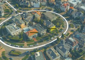
Above: A “new-user” 1-person firm scanned this complex historic building in five hours with 75 set-ups of the BLK360 and created final drawings. Credit: Southwest Scanning. Almost everyone is familiar with splashy announcements of new products. For much of my career with Trimble and with Leica Geosystems, I personally drove many product introductions, so I’m tuned into...

The Evolution of Using Lidar
Above: Gary Rust (left) and Anthony Whitlock from Springs Utilities pose with their LiDAR USA HiWay Mapper HD. The history of a Colorado utility systematically deploying lidar technology reveals lidar’s journey as an asset. Located at the base of Pikes Peak on the front range of the Colorado Rockies, Colorado Springs Utilities is a city-owned...
Embrace the Mesh
Above: A full 3D textured model of San Francisco produced through Skyline’s PhotoMesh 3D Reconstruction software and streamed for visualization and analytics in Skyline’s TerraExplorer. Surveyors and photogrammetrists capture reality data. But to model, manage, and provide access to massive and complex datasets—to provide your clients with true 3D mesh reality capture—you’re going to need...

UAS + Lidar = “X-ray” Vision
Image above: The same area as shown in the picture to the right with the ground extracted and the trees filtered out. A construction/survey project proves that UAS-borne lidar can penetrate tree cover to yield accurate ground data with improved post-processing times compared to photogrammetric solutions. I’m the VP of remote sensing at Morris P....

Point Clouds for Water Conservation
Image above: The Lake Mead region of Las Vegas, Nevada. A project to identify and quantify irrigated landscapes in Las Vegas demonstrates the advantages of using lidar to save precious natural resources. Persistent drought conditions in the western United States are dramatically reflected in the steady diminution, over the past 15 years, of Lake Mead,...

Mobile Mapping Evolves
Image above: A colorized point cloud from a subway collect in Los Angeles, California. Credit: Joe Feyder, PLS, R.E.Y Engineers, INC., and John Jaramillo, Los Angeles County Metropolitan Transportation Authority. While lidar has been a standard geospatial tool for many years, the requirements of companies using it have been rapidly changing and evolving. Therefore, lidar...